
Offering group discounts!
Reserve with a 20% deposit. The balance isn't due until 60 days before departure, and cancellations more than 60 days out get a full deposit refund. How booking works →
 Region
Everest Region
Region
Everest Region
 Duration
14 Days
Duration
14 Days
 Difficulty
Strenuous
Difficulty
Strenuous
 Max. Altitude
5545 m
Max. Altitude
5545 m
 Prime Activity
Trekking In Nepal
Prime Activity
Trekking In Nepal
 Season
(March-May) (September-November)
Season
(March-May) (September-November)
 Group Size
1-12 people
Group Size
1-12 people
The Everest Base Camp, Cho La Pass, and Gokyo Trek is one of the most comprehensive trekking experiences in the Himalayas. Unlike the conventional Everest Base Camp trail, this trek combines three iconic destinations into a circular route: Everest Base Camp, the high-altitude Cho La Pass, and the pristine Gokyo Lakes.
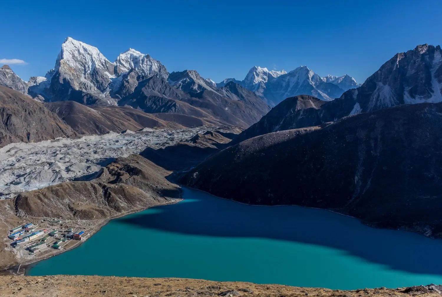
Starting from Lukla, the trail follows the classic EBC route through Namche Bazaar, Tengboche, and Dingboche before reaching Everest Base Camp and Kala Patthar. From there, instead of retracing your steps, you continue towards Cho La Pass (5,420m) and descend into the Gokyo Valley, ending with spectacular views of the turquoise Gokyo Lakes and a panoramic climb up Gokyo Ri.
The complete circuit covers approximately 130 km over 15 to 17 days, passing through Sherpa villages, rhododendron forests, glacial moraines, and extreme alpine terrain. You spend nights at altitudes exceeding 5,000m, making proper acclimatization an essential part of the itinerary.
This trek suits intermediate trekkers and reasonably fit beginners who want more than the standard EBC trek. It rewards those willing to push further with incredible landscapes, quieter trails, and a sense of achievement that the classic route cannot match.
The classic Everest Base Camp Trek is an incredible experience; however, one limitation is that you return through the same trail. This trek creates a circular route, allowing you to experience new landscapes and destinations throughout the journey.
The Everest Base Camp Cho La Pass Gokyo Trek follows a circular route through the heart of the Khumbu region, meaning you do not repeat the same trail twice.
The journey begins with a scenic flight from Kathmandu to Lukla (2,800m), followed by a trek to Phakding on the first day. The second day takes you to Namche Bazaar (3,440m), the bustling trading hub of the Everest region, where you spend an acclimatization day before gaining more altitude.
From Namche, the trail climbs through Tengboche, home to the Khumbu region’s famous monastery, before descending briefly and ascending again towards Dingboche (4,400m) for another acclimatization day. The route then continues through Lobuche and Gorakshep before reaching Everest Base Camp (5,364m) and Kala Patthar (5,545m).
Instead of returning along the same route, the trail turns west towards Dzongla and crosses the challenging Cho La Pass (5,420m). After crossing the pass, you descend into the Gokyo Valley through Thagnak and arrive at Gokyo village beside the sacred lakes. A morning climb to Gokyo Ri (5,357m) completes the high-altitude highlights before descending through Dole and returning to Namche. The trek concludes with the final walk to Lukla and a flight back to Kathmandu.


Spring is one of the two best seasons for this trek. The lower sections of the route between Lukla and Namche come alive with blooming rhododendrons in shades of red, pink, and white. Daytime temperatures are comfortable for trekking, although nights remain cold at higher elevations. Visibility is generally good, with clear morning skies followed by occasional afternoon clouds. Snow on Cho La Pass begins to melt from late April onwards, making the crossing more manageable. The trails are also slightly quieter than in autumn, offering a more relaxed experience.
Autumn is the most popular trekking season in Nepal for good reason. The monsoon clears by late September, leaving behind stable weather, dry trails, and exceptionally clear mountain views. Everest, Kala Patthar, and Gokyo Ri are at their most photogenic during this season. Cho La Pass is usually in excellent condition with less snow than in winter or early spring. Expect busy trails, especially between Namche and Everest Base Camp. Booking teahouses in advance during October is strongly recommended.
Winter trekking is possible, but it is considerably more challenging. Temperatures at higher elevations can drop well below -15°C, while strong winds make exposed areas feel even colder. Heavy snowfall can close Cho La Pass, making it impossible to complete the full circuit. Some teahouses around Gokyo and Dzongla reduce their services or close entirely during this period. However, the trails are almost empty, and mountain views are often crystal clear. Winter trekking is best suited to experienced trekkers with proper cold-weather equipment.
The monsoon brings heavy rainfall to the lower sections of the trail, making paths slippery and increasing the risk of landslides below Namche. Leeches are common in forested areas, and persistent cloud cover often hides mountain views for days. Flights to and from Lukla are frequently delayed or cancelled. Although the Khumbu Valley becomes lush and green, the combination of poor visibility and difficult trail conditions makes monsoon the least recommended season for this trek.
The Everest Base Camp Cho La Pass Gokyo Trek is considered moderately challenging to challenging. Although it is not a technical climbing expedition, it requires good physical fitness, previous multi-day trekking experience, and proper altitude awareness.
Most trekking days involve five to seven hours of walking, while some days extend to eight or nine hours. The trail includes steep ascents, rocky descents, glacial terrain, and long valley walks. Crossing Cho La Pass is the most demanding day, combining a long climb, glacier crossing, and descent in a single day.
This trek exceeds 5,000 metres on multiple occasions. The highest overnight stop is Gorakshep (5,180m), while Kala Patthar reaches 5,545m. Two acclimatization days at Namche Bazaar (3,440m) and Dingboche (4,400m) are essential for reducing the risk of Acute Mountain Sickness (AMS). Ascending gradually, staying hydrated, and monitoring your health are critical.
Cho La Pass (5,420m) distinguishes this trek from the standard Everest Base Camp route. The ascent involves loose rocks, boulders, and a glacier that often remains icy even during peak trekking seasons. Although technical climbing equipment is generally unnecessary, you should be comfortable walking on uneven, exposed terrain. Trekking poles are highly recommended, while microspikes or crampons may be required depending on trail conditions.
Travel insurance is essential for anyone trekking in the Everest region, especially when crossing high-altitude passes like Cho La Pass. Your insurance should cover medical emergencies, helicopter evacuation, trip interruptions, altitude sickness, injuries, and weather-related delays.
Helicopter evacuations from remote areas such as Gokyo or Everest Base Camp can cost thousands of dollars, making comprehensive insurance extremely important.
A suitable travel insurance policy should include:
Purchase your insurance before arriving in Nepal, as many providers require coverage to begin before departure. Carry both printed and digital copies of your policy throughout the trek.
Nepal offers a Visa on Arrival to citizens of most countries (except Bhutan) at Tribhuvan International Airport and designated land border crossings.
Visa Fees (2026)
Required Documents
Your visa does not include trekking permits, travel insurance, or guide fees. If your trek exceeds your visa validity, you must extend it through Nepal Immigration before it expires.
Breakfast usually includes porridge, eggs, toast, Tibetan bread with jam or honey, tea, or coffee. Lunch and dinner menus are similar throughout the trek, offering dal bhat, fried rice, noodles, pasta, soups, momos, and potato dishes. Hot drinks such as ginger tea, lemon tea, and hot chocolate are widely available.
Tap water is not safe to drink. Purchase boiled or filtered water at teahouses or carry water purification tablets or a portable filter.
The teahouse experience changes noticeably as you gain altitude. Below Namche, accommodation is generally more comfortable with better facilities and a wider menu selection. Above Dingboche, rooms become colder, hot showers become less reliable, and facilities are more basic. Evenings are usually spent in the communal dining room around the stove, sharing stories with fellow trekkers.
AMS can affect anyone regardless of age or fitness level. Common symptoms include headaches, nausea, dizziness, loss of appetite, fatigue, and poor sleep. If symptoms appear, do not continue ascending. Rest at the same altitude or descend if symptoms worsen. Your guide should monitor your oxygen saturation regularly using a pulse oximeter.
The itinerary includes dedicated acclimatization days at Namche Bazaar and Dingboche. These rest days are essential for reducing the risk of altitude sickness. Follow the principle of climbing high and sleeping low whenever possible, stay hydrated, and avoid alcohol during the first few days at altitude.
Cho La Pass introduces an additional weather challenge. If heavy snowfall or poor conditions make the crossing unsafe, your guide may delay or reroute the itinerary. Flexibility is important, as no mountain crossing is worth risking your safety.
Helicopter evacuation is available from most locations along the route during genuine medical emergencies. This is why comprehensive travel insurance covering emergency evacuation above 6,000 metres is essential.
A few simple preparations before arriving in Nepal can make your trek significantly smoother.
Choosing the right trekking company is just as important as choosing the trek itself. Experienced local support can make a significant difference when trekking above 5,500 metres.
With Nepal Outdoor Expeditions, you’re not simply hiring a guide. You’re trekking with an experienced team dedicated to helping you complete your journey safely and confidently.
Rooms are basic, normally with twin beds, a pillow, and a blanket. A good-quality sleeping bag rated to at least -15°C is crucial, as rooms are not heated. The communal dining hall is typically the warmest area in the lodge, heated by a wood or yak-dung stove, and it is where most trekkers spend their evenings.
From Lukla to Namche, the teahouses are well-equipped, and some offer attached bathrooms. Above Namche, shared bathrooms become more common. In locations like Dzongla and Thagnak, facilities are simpler, and lodges are smaller. Gokyo fills up quickly during peak seasons, so booking accommodation in advance is advisable.
Charging electronic devices is available throughout the trek for a small additional fee. At higher altitudes, where electricity supply can be limited, carrying a power bank is a practical necessity.
When heading out on a trek to Everest Base Camp, Cho La Pass, and Gokyo, you will be walking through very different climates. Packing well in advance is important because you may be in warm valleys one day and crossing snowy high passes the next.
When doing the Cho La Pass trek and the Gokyo Trek, proper clothing is essential due to changing weather and high-altitude conditions. Start with a moisture-wicking base layer, such as synthetic or merino wool T-shirts and long-sleeved tops, which help keep sweat away from your body and dry quickly. Cotton should be avoided, as it holds moisture and can make you cold.
Thermal tops and bottoms are important for cold nights, especially above 3,500 meters. Add a mid-layer, such as fleece jackets or pullovers that provide warmth without being too bulky.
For the outer layer, a waterproof and windproof hardshell jacket with a hood and rain pants is necessary to protect against snow, rain, and strong winds. For the lower body, carry at least two pairs of quick-dry hiking pants and one pair of shorts for lower-altitude days, along with synthetic underwear. Footwear should include sturdy waterproof trekking boots, thick wool-blend socks, and thinner socks to help prevent blisters.
Accessories such as a sun hat, wool beanie, UV-protected sunglasses, gloves, glove liners, and a buff or scarf are also essential for protection from sun, wind, and cold conditions in the Everest region.
Technical equipment plays an important role in safety and comfort, especially on challenging sections like Cho La Pass. Trekking poles help with balance and reduce strain on the knees during long descents. Gaiters keep your feet dry and protect against mud and debris, while crampons are needed for icy or steep sections. In more technical conditions, an ice axe may also be required.
A high-quality sleeping bag rated between -10°C and -20°C, along with a sleeping bag liner for extra warmth, is important for cold nights. A lightweight sleeping pad helps block the cold from the ground and improves comfort in teahouses or tents. A headlamp with extra batteries is useful for early starts or power outages. A small multitool or knife can also be helpful in emergencies.
A proper hydration system, either water bottles or a hydration bladder, along with water purification tablets or a filter, is essential to avoid dehydration at high altitude.
Maintaining your energy levels is crucial while trekking at high altitude. Carry snacks such as energy bars, nuts, and electrolyte powders to replenish energy between meals. Foods like rice, pasta, oats, and potatoes provide carbohydrates, while eggs, lentils, nuts, and lean meat supply protein to support muscle recovery. Healthy fats from nuts and seeds also provide sustained energy during long trekking days.
Above 4,000 meters, it is better to eat small, frequent meals rather than heavy portions, as digestion becomes slower at altitude. Warm drinks such as herbal teas and soups help with hydration and keep the body warm during cold evenings.
Maintaining hygiene in remote areas is important, but your personal items should remain lightweight and practical. Carry high-SPF sunscreen and lip balm to protect yourself from intense sun and wind. Wet wipes and a quick-dry towel are useful when water is limited. A personal first-aid kit should include pain relievers, blister treatment, bandages, and any prescription medication you require.
Carry a power bank with at least a 10,000 mAh capacity, a universal adapter, and extra charging cables to keep your devices powered. Always keep your passport, trekking permits, travel insurance documents, and enough cash for expenses along the trail.
Smart packing makes trekking easier and reduces unnecessary strain. Most gear can be packed in a soft duffel bag (90–120L) with a waterproof lining, especially if porters carry your luggage. A smaller daypack, ideally under 10 kg, should hold daily essentials such as water, snacks, a camera, and extra clothing layers.
Packing cubes or small organizers help keep clothing and equipment organized and easy to access. Clearly labelling your bags also helps prevent confusion during transport and equipment handling.
Although optional, a few extra services can improve your comfort throughout the trek. Renting equipment in Kathmandu is a popular way to reduce luggage weight. Jackets, sleeping bags, trekking poles, and crampons are widely available. Lightweight sleeping pads, sleeping bag liners, spare batteries, a small repair kit, and an extra SIM card can also prove useful during longer treks or emergencies.
If you prefer not to buy bulky or expensive equipment, many rental shops operate in Thamel, including Kathmandu Shona Alpine, Kathmandu Himalaya Gears, and Kathmandu Gears Nepal. Renting allows you to travel lighter, but you should always inspect equipment carefully for wear and damage before hiring it. Most rental shops require a passport copy and a refundable deposit, and bargaining is common. Renting items such as sleeping bags, trekking poles, crampons, and jackets can be a cost-effective option.
In 2026, trekkers following this route must obtain two permits: the Khumbu Pasang Lhamu Rural Municipality Permit and the Sagarmatha National Park Entry Permit. A TIMS card is no longer mandatory for this trek, although some trekkers still obtain one as a souvenir.
This permit is required to enter Sagarmatha National Park, which covers the area from Lukla to Everest Base Camp and the Gokyo region.
Note: Trekking without this permit may result in a fine of up to NPR 20,000 and possible removal from the park.
This local permit is required to enter the Khumbu region, including Cho La Pass. The permit supports local development and helps authorities monitor visitor numbers.
Note: No additional restricted-area permits are required if you remain on the standard trekking route.
Altitude sickness, also known as Acute Mountain Sickness (AMS), occurs when your body cannot adapt quickly enough to lower oxygen levels at high elevations. It is one of the most common health concerns on the Everest Base Camp, Cho La Pass, and Gokyo Trek, where elevations exceed 5,000 meters. AMS can range from mild discomfort to a serious, life-threatening condition if left untreated.
Preventing altitude sickness depends largely on proper pacing, hydration, and nutrition.

Tenzing Sherpa
Have questions? Our travel specialists are here to help plan your perfect adventure.
Chat on WhatsAppStart Altitude: 2,800m / 9,186 ft End Altitude: 2,610m / 8,563 ft Elevation Change: -190m descent Meals: Breakfast, Lunch, Dinner Accommodation: Teahouse / Lodge The trip starts with an early morning flight from Kathmandu to Lukla's Tenzing Hillary Airport, which is known as one of the most exciting short flights anywhere in the world. After landing and grabbing a quick breakfast in Lukla, the trail heads downhill along the Dudh Koshi valley toward Phakding. It's a gentle first day on the trail, mostly downhill, which gives your legs an easy start before the harder days ahead. Phakding is a small village along the river, and it's a nice place to settle in for the first night. Since the walking is light on this day, you'll have plenty of time to relax once you arrive, get used to the pace of teahouse life, and enjoy dinner while chatting with your guide about the days ahead. Overnight in Phakding.
Start Altitude: 2,610m / 8,563 ft End Altitude: 3,440m / 11,286 ft Elevation Gain: 830m / 2,723 ft Meals: Breakfast, Lunch, Dinner Accommodation: Teahouse / Lodge Today's trail follows the Dudh Koshi River, crossing back and forth over five suspension bridges along the way. The fifth bridge is one of the highest suspension bridges in the world, and crossing it gives you a real sense of how big this landscape is. About three hours in, you'll enter Sagarmatha National Park, which is a UNESCO World Heritage Site, and from there a steep climb leads you up to Namche Bazaar. Namche is the main trading hub of the Khumbu region and is often called the gateway to Everest. It's a lively town built into the side of a hill, with shops, bakeries, and lodges everywhere. After the climb up, you'll have the evening to rest, grab a warm drink, and take in your first proper look at life in the Khumbu. Overnight in Namche.
Altitude: 3,440m / 11,286 ft Meals: Breakfast, Lunch, Dinner Accommodation: Teahouse / Lodge This is a rest day, but it's not really optional. Spending a full day in Namche before heading higher makes a big difference in lowering the risk of altitude sickness. Instead of sitting around, the day usually includes a visit to the Sherpa Museum and a hike up toward the Everest View Hotel, which has one of the best panoramic views around, taking in Everest, Ama Dablam, and the mountains that surround them. After soaking in the views, you'll head back down to Namche for a second night. It's a good chance to slow down, let your body adjust to the altitude, and maybe do a bit of shopping or people watching in town before continuing higher into the mountains. Overnight in Namche.
Start Altitude: 3,440m / 11,286 ft End Altitude: 3,870m / 12,697 ft Elevation Gain: 430m / 1,411 ft Meals: Breakfast, Lunch, Dinner Accommodation: Teahouse / Lodge Leaving Namche, the trail winds through rhododendron and pine forest, with regular views of Ama Dablam appearing up ahead. The walk takes about five hours and passes through several small Sherpa villages along the way, giving you a good look at daily life in the region. Once you reach Tengboche, you'll have the chance to visit Tengboche Monastery, which is the most important and respected monastery in the whole Khumbu area. The monastery sits with Ama Dablam rising dramatically behind it, a peak that many consider one of the most beautifully shaped mountains in the Himalayas. Overnight in Tengboche.
Start Altitude: 3,870m / 12,697 ft End Altitude: 4,400m / 14,436 ft Elevation Gain: 530m / 1,739 ft Meals: Breakfast, Lunch, Dinner Accommodation: Teahouse / Lodge The trail dips down briefly and crosses a wooden bridge before climbing up through Pangboche, one of the largest Sherpa villages in the area. Above 4,000 meters, the trees start to thin out, and the landscape opens up into wide alpine terrain. Lunch is usually taken in Somare before the final stretch up to Dingboche. Dingboche is a wide, sheltered valley surrounded by tall peaks, and it feels noticeably different from the forested villages lower down. It's a good spot to rest, look around at the scenery, and get ready for the second acclimatization day ahead. Overnight in Dingboche.
Altitude: 4,400m / 14,436 ft Meals: Breakfast, Lunch, Dinner Accommodation: Teahouse / Lodge A second acclimatization day helps your body keep adjusting safely as you go higher. Most people spend the morning hiking up Nagarjun Hill, right above Dingboche, which rewards you with sweeping views of Makalu, Island Peak, Lhotse, and the ridgelines around the valley. After coming back down for lunch, the rest of the afternoon is free. Some people relax at the lodge, others wander around the village or just sit outside and take in the mountain views. Either way, it's a relaxed and easy day meant to help your body catch up before pushing higher. Overnight in Dingboche.
Start Altitude: 4,400m / 14,436 ft End Altitude: 4,930m / 16,171 ft Elevation Gain: 530m / 1,739 ft Meals: Breakfast, Lunch, Dinner Accommodation: Teahouse / Lodge The day starts with an easy walk to Thukla, a small stop where many trekkers pause for tea, since there's nothing else between there and Lobuche. From Thukla, the trail climbs steeply up to Thukla Pass, where you'll pass a group of stone memorials built in honor of climbers who lost their lives on Everest expeditions. It's a quiet and moving spot that puts the scale and risk of the mountain into perspective. After the pass, the trail continues to Lobuche, a small settlement sitting right at the edge of the Khumbu Glacier's moraine. Overnight in Lobuche.
Start Altitude: 4,930m / 16,171 ft End Altitude: 5,364m / 17,598 ft Highest Point: Everest Base Camp 5,364m / 17,598 ft Meals: Breakfast, Lunch, Dinner Accommodation: Teahouse / Lodge This is the day the whole trek has been building toward. The morning trail follows the edge of the Khumbu Glacier to Gorakshep, the last village before base camp. After dropping your bags and grabbing a quick lunch, you'll continue over rocky glacial terrain until you finally reach Everest Base Camp. Standing at the foot of the world's highest mountain, with the Khumbu Icefall in view ahead, is a moment that stays with most people long after the trek ends. Once you've taken it all in, you'll head back to Gorakshep for the night. Overnight in Gorakshep.
Start Altitude: 5,180m / 16,995 ft High Point: 5,545m / 18,192 ft (Kala Patthar) End Altitude: 4,800m / 15,748 ft Meals: Breakfast, Lunch, Dinner Accommodation: Teahouse / Lodge The day begins early, well before sunrise, with a climb up to Kala Patthar. The 360-degree view from the top gives you the closest and most dramatic look at Everest you can get without a climbing permit, and it's often the highlight of the whole trip for many trekkers. After watching the sunrise, you'll head back down through Gorakshep and then turn west toward Dzongla. It's a quieter part of the trail, and reaching Dzongla marks the start of the next challenge, crossing Cho La Pass. Overnight in Dzongla.
Start Altitude: 4,800m / 15,748 ft High Point: 5,420m / 17,782 ft (Cho La Pass) End Altitude: 4,800m / 15,748 ft Meals: Breakfast, Lunch, Dinner Accommodation: Teahouse / Lodge This is one of the toughest days of the whole trek. The climb up to Cho La Pass involves steep, rocky ground followed by a short icy section that can be slippery no matter the season, so trekking poles and microspikes are strongly recommended. The effort is worth it, though, since the views from the top are some of the best on the entire route. Coming down the other side, the trail leads to Thagnak and then continues through the open Gokyo Valley to Gokyo village, which sits right on the edge of the third and largest of the sacred Gokyo Lakes. Overnight in Gokyo.
Start Altitude: 4,800m / 15,748 ft High Point: 5,357m / 17,575 ft (Gokyo Ri) End Altitude: 4,200m / 13,780 ft Meals: Breakfast, Lunch, Dinner Accommodation: Teahouse / Lodge An early climb up Gokyo Ri offers one of the best views in the entire Everest region. From the top, you can see four mountains over 8,000 meters at once, Everest, Lhotse, Makalu, and Cho Oyu, all lined up together, with the Ngozumpa Glacier, the largest glacier in Nepal, stretching out below. After heading back down to Gokyo, the trail passes along the turquoise Gokyo Lakes before continuing downhill to Dole for the night. It's a good day to slow down a little and enjoy the scenery on the way back down. Overnight in Dole.
Start Altitude: 4,200m / 13,780 ft End Altitude: 3,440m / 11,286 ft Elevation Loss: 760m / 2,493 ft Meals: Breakfast, Lunch, Dinner Accommodation: Teahouse / Lodge Leaving the high mountains behind, the trail heads down through a series of Sherpa villages, and the landscape slowly softens as you lose altitude. The walk back to Namche passes through familiar ground, though everything feels a little different heading downhill compared to the climb up. Back in Namche, there's time to browse the shops for souvenirs and relax before an early start the next morning. It's a good last chance to enjoy the town before heading back toward Lukla. Overnight in Namche.
Start Altitude: 3,440m / 11,286 ft End Altitude: 2,800m / 9,186 ft Elevation Loss: 640m / 2,100 ft Meals: Breakfast, Lunch, Dinner Accommodation: Teahouse / Lodge After an early breakfast, the final day of trekking follows the trail back to Lukla, taking around seven hours. The walk is easier on the lungs at this point since you're heading back down, but it's still tough on the knees after so many days on the trail. Arriving in Lukla marks the end of the trek, and the evening is a great time to celebrate with your guide and fellow trekkers over a well-earned meal. It's a nice way to wrap up the trekking part of the journey before flying back to Kathmandu. Overnight in Lukla.
Altitude: 1,400m / 4,593 ft (Kathmandu) Meals: Breakfast Accommodation: Hotel in Kathmandu An early morning flight takes you back to Kathmandu, and the views of the Himalayas from the plane give you one last look at the mountains you've spent the past two weeks exploring on foot. It's a fitting way to end the trek, watching the landscape shrink below you after walking through so much of it. On arrival in Kathmandu, you'll be transferred to your hotel by private car, where a hot shower and a comfortable bed are waiting. The rest of the day is free, giving you time to rest, reflect on the trip, and slowly ease back into city life. Overnight in Kathmandu.
See what past travelers are saying about their experience with Nepal Outdoor Expeditions.
Because your next adventure is impatiently waiting for you.
Last Minute Note: Grab incredible deals on the last minute departure / Book spontaneous trips to hip destinations with limited-time offers and discounted price
Not sure of your dates yet? Hold a departure with a 20% deposit. Cancel more than 60 days out and your deposit is refunded in full. Your first date change is free. If a departure doesn't reach minimum numbers, we'll offer you the nearest alternative date or a full refund, and we'll let you know at least 30 days out.
Before you think of or actually plan any adventurous or relaxing tours, travels, or treks with Nepal Outdoor Expeditions.
If you cancel more than 60 days before departure, we refund your deposit in full. Between 30 and 60 days, the 20% deposit is retained. Inside 30 days the trip cost is non-refundable, since by then we've already paid for your permits, flights, and teahouse bookings. Full detail on our booking page.
20% to reserve your place, with the balance due 60 days before departure. On this trek that's $315 to book and $1,260 two months before you fly. If you're booking within 7 days of departure, the full amount is due at booking.
Yes, as long as you let us know at least 30 days before your original departure date, your first change is free. Any change after that, or a change requested inside 30 days, is $200 per person.
Everest Base Camp Chola Pass Gokyo Trek