Overview
The Manaslu and Annapurna Trek is a remarkable journey that combines two of Nepal’s most iconic Himalayan regions into one unforgettable adventure. The trail begins in the remote and culturally rich Manaslu region, where the paths feel quieter and the landscapes remain raw and untouched. As you walk through deep valleys, dense forests, and traditional mountain villages, the towering presence of Mount Manaslu slowly comes into view, creating moments that feel both humbling and inspiring.
As the journey continues, the trek gradually connects with the famous Annapurna region, bringing a new change in scenery and atmosphere. The route becomes more lively with trekkers from around the world, yet the dramatic mountain views and diverse landscapes remain just as breathtaking. From peaceful villages and ancient monasteries to high mountain passes and wide Himalayan panoramas, the Manaslu and Annapurna Trek offers a perfect blend of adventure, culture, and natural beauty that stays with you long after the trek is over.
Highlights
-
You can experience the wilderness of Manaslu and the diverse landscapes of the Annapurna region.
-
You get to cross the highest passes, like Larkya La Pass and Thorong La Pass.
-
You can explore the villages, monasteries, and diverse culture of the Annapurna region.
-
You get to visit the sacred Muktinath temple of both Hindus and Buddhists.
-
You can encounter wildlife species in both conservation areas.
-
You can witness the towering peaks of Annapurna, Manaslu, Dhaulagiri, and other Himalayas.
Detailed Itinerary
Drive from Kathmandu to Machhakhola
Description
Your adventure kicks off with a long but rewarding drive out of the Kathmandu Valley. As you roll along the Prithivi Highway, the city chaos slowly gives way to open river valleys, and before long you're tracing the banks of the Trishuli and Marshyangdi Rivers. The road weaves past small roadside villages, terraced hillsides, and the occasional waterfall tumbling down the cliffs above you. Keep your eyes to the left on clear days and you'll catch your first glimpses of the Himalayan giants waiting ahead. After crossing the Trishuli River, the route swings toward Dhading Bensi and then follows the Dorandi Khola north to Arughat. From there, you pass through the traditional Gurung and Magar communities around Sotikhola before finally pulling into Machhakhola at an 900 meters as the day winds down. It's a long day in the seat, but it sets the tone for everything ahead.
Trek from Machhakhola to Jagat
Description
Day two is where the trekking properly begins, and it's a beautiful introduction to what the Manaslu region is all about. You start by crossing the Tharo Khola and making your way upstream toward Khola Beni. The trail then leads across a bridge to the small settlement of Khorlabesi, and shortly after you reach Tatopani, where natural hot springs bubble up right along the trail. It's a tempting early stop. From Tatopani, you follow the eastern bank of the Budhi Gandaki River, crossing suspension bridges over the river and later over the Yaru Khola before climbing the stone stairs at Thado Bharyang. The final stretch brings you onto the west bank of the Budhi Gandaki, up and over a ridge, and down into Jagat. This is where your special Manaslu Conservation Area permit comes into play, as Jagat (1,350 meters) marks the official entry into the protected zone.
Trek from Jagat to Deng
Description
Leaving Jagat after breakfast, you climb above the village before the trail drops back down to Sirdibas and then runs along the wide, open floor of the Budhi Gandaki River Valley. The river feels like a constant companion through this section, loud and grey with glacial silt. After crossing a suspension bridge, you walk into Philim, one of the larger traditional Gurung settlements in this part of the valley. It's a good place to catch your breath and take in the feel of the community. Beyond Philim, the trail heads north through millet fields toward Ekle Bhatti before descending grassy slopes to cross the Budhi Gandaki once more. The path then winds through bamboo forests along the river's east bank, passing through Pewa before arriving at Deng (2,130 meters). By the time you walk in, the elevation gain will have earned you a solid appetite for dinner.
Trek from Deng to Namrung
Description
Today the landscape starts to shift noticeably. Climbing past Rana toward Bhi, you move through rhododendron, fir, and pine forests that feel increasingly remote and wild. The trail crosses the Budhi Gandaki several times throughout the day, and with each crossing you feel yourself edging closer to the Tibetan plateau. A detour up to Prok Village rewards you with a fine view of the Siringi Himal rising steeply to the north. As you near Namrung at an 2630 meters, the cultural landscape changes just as dramatically as the natural one. You're only 6 kilometers from the Tibetan border here, and it shows in the monasteries, the prayer flags, the stone architecture, and the language spoken by the locals. Namrung has a quiet, almost otherworldly quality to it that makes the effort of getting here feel entirely worthwhile.
Trek from Namrung to Shyala
Description
A shorter day on the trail, but don't let that fool you as the scenery more than compensates for the distance. After breakfast, you thread through rhododendron, fir, and oak forests toward Lihi, with Manaslu, Ganesh Himal, and Himchuli filling the skyline to an almost unreasonable degree. It's the kind of mountain panorama that stops you mid-stride. You pass through Sho before arriving at Lho, a village of traditional stone houses where Tibetan-influenced culture is very much alive in daily life. From Lho, roughly an hour and a half of walking brings you into Shyala (3,543 meters), a charming high-altitude settlement with a terrific view of Ngadi Chuli looming to the southwest. With a shorter day behind you, there's time in the afternoon to simply sit with a cup of tea and take it all in.
Trek from Shyala to Samagaun via Pungyen Monastery
Description
Starting the day with pine and rhododendron forest once again, you make your way toward Pungyen Monastery at an 3,500 meters, which sits quietly above the valley with commanding views of Manaslu directly in front of you. It's one of those places that feels genuinely peaceful, and worth slowing down for before you move on. From the monastery, the trail drops steadily toward Samagaun, just 5 kilometers away. As you approach the village through its traditional Kani Gate entrance, Manaslu and Himalchuli stand tall to the south while Ganesh Himal greets you from the east. Samagaun is the largest village in the Manaslu Conservation Area, home to the warm and welcoming Nubri people. Spend the evening absorbing the atmosphere here because this village has a special quality that's hard to put into words.
Acclimatization at Samagaun
Description
After several consecutive days of climbing, your body deserves a day to catch up with the altitude, and Samagaun at an 3,530 meters is genuinely one of the better places along the entire route to spend a rest day. For those who find sitting still difficult, a hike up to Birendra Tal or even all the way to Manaslu Base Camp at 4,800 meters is a rewarding way to spend the morning while still following the golden acclimatization rule of climbing high and sleeping low. In the afternoon, a slow wander through the village itself is worth your time. The stone houses, the local tea shops, the monks going about their day. It all adds up to a pretty vivid portrait of life at altitude. Take it easy tonight. Tomorrow the climbing resumes.
Trek from Samagaun to Samdo
Description
A relatively gentle day on the trail, which is a welcome change before the big push ahead. Descending first through terraced fields and past old mani walls, you drop down to the Budhi Gandaki River and cross the trail junction where routes branch off toward Birendra Tal and the Manaslu Base Camp. Continuing upstream, you reach Kermo Kharka before crossing a wooden bridge over the river and arriving at the Kani gate marking the entrance to Samdo. It's a small and quiet village, but the setting is spectacular. Pangpoche Peak at 6,620 meters dominates the view, and on a clear evening the light hitting those upper ridges can be extraordinary. An early night here makes good sense, as the next few days are the most demanding of the entire journey.
Trek from Samdo to Dharamsala
Description
Today's destination, Dharamsala, also known locally as Larkya La Phedi, is the last proper stopping point before the Larkya La Pass. The trail crosses suspension bridges over the Budhi Gandaki early on, then climbs gradually past mani walls, stone huts, and the ghostly remains of Larkya Bazaar, which was once a busy salt trading hub connecting communities across the valley. Dharamsala at an altitude of 4,480 meters itself is more of a high-altitude shelter than a traditional teahouse village, but it serves its purpose well. This is the highest rest point on the entire Manaslu Circuit. Get to bed early, eat well, drink plenty of water, and make sure your gear is organized the night before. Tomorrow is the big one.
Trek from Dharamsala to Bimthang over Larkya La Pass
Description
This is the day the whole trek has been building toward. You'll start early, well before sunrise for most groups, following the ascending trail north toward the Larkya Glacier. The path crosses glacial moraines in the dark and early morning cold before the gradient steepens toward the pass itself. It's tough going, but the sky starts to lighten just as you need it most, and the views that open up on the approach are extraordinary. From the top of the Larkya La at 5,106 meters, you can see Manaslu, Naike Peak, Pangboche Peak, Larkya Peak, Annapurna II, Kusum Kanguru, and Himlung Himal all at once. Take your time up there. The descent to the west is long. You drop first to Bhimthakoti at 3,942 meters, covering about 6.9 kilometers from the pass, then continue through meadows and into the treeline before the trail leads past an old mani wall and a small rest house and finally into Bimthang. Your legs will know they've worked for it, but there's a deep satisfaction that comes with a day like this one.
Trek from Bimthang to Dharapani
Description
After yesterday's high-altitude crossing, today is all about coming back down to earth, quite literally. The descent is steep and sustained, dropping over 1,800 meters by the time you reach Dharapani at an 1,860 meters. The trail follows the Surki Khola down before joining the Dudh Khola and continuing past Soti Khola toward Gho. From there you move through terraced farmland and forested slopes along the north bank of the Dudh Khola to reach the Gurung village of Tilije, where the valley widens and the air feels noticeably warmer and thicker. The final stretch takes you through Thonje and across a suspension bridge over the Marsyangdi River into Dharapani, where the Annapurna Circuit route begins. Your knees will have earned their rest tonight.
Trek from Dharapani to Chame
Description
Welcome to the Annapurna Circuit, the second chapter of this expedition. The trail from Dharapani follows dense pine, fir, oak, and rhododendron forests alongside the Marsyangdi River, with Lamjung Himal and Annapurna II appearing through the trees as reliable companions. The route passes through Danakyu Village before climbing steeply to Timang, after which the trail eases off on the approach to Chame. Chame at an 2,670 meters serves as the administrative headquarters of the Manang district and has more facilities than most places you've stayed in recently. After settling in, it's worth strolling down to the natural hot spring on the banks of the Marsyangdi River. After the accumulated mileage of the past several days, soaking in warm water might be the best decision you make all trip.
Trek from Chame to Upper Pisang
Description
Leaving Chame, you follow the northern bank of the Marsyangdi River as the valley begins to narrow and deepen. One of the more dramatic features along today's route is the Paungda Danda Rock Face, a sweeping curved cliff that rises 1,500 meters above the river. It's one of those geological features that makes you stop and stare for a moment longer than you planned. From there, a steep climb through pine forest brings you up to a ridge before the trail descends toward the floor of the Manang Valley and Lower Pisang. A short climb on the far side of the river, about 50 meters, leads you up to Upper Pisang (3,250 meters). The higher village is worth the extra effort as it sits on an open shelf with far better views than its lower counterpart, including a fine outlook across to the Pisang and Annapurna peaks.
Trek from Upper Pisang to Manang
Description
Today's trail climbs northwest from Upper Pisang and dips into a pine forest where a small Green Lake sits hidden among the trees. It's an unexpected little discovery. Beyond the forest, the village of Ghyaru opens up one of the finest mountain panoramas of the entire trek, with Annapurna II, III, and IV, Tilicho Peak, Pisang Peak, and Gangapurna all laid out in front of you. The route continues through Tibetan-influenced settlements decorated with chortens and prayer flags before reaching Ngawal Village, about two hours from Ghyaru. From Ngawal, Manang is not far, and just before you arrive, there's a worthwhile detour to Braga Monastery, the largest in the area and genuinely worth the short walk. Manang at an 3,519 meters itself has a lively, almost festive energy to it, a real hub for trekkers heading toward Thorong La, and a welcome change after days of quieter high-altitude villages.
Exploration and acclimatization day at Manang
Description
Your second acclimatization day of the trip, and Manang is a genuinely enjoyable place to spend it. The two most popular hikes from here are up to Ice Lake and Gangapurna Lake, both of which offer spectacular views and the added benefit of taking you higher before you sleep lower, exactly what your body needs at this stage. If hiking isn't appealing, the Himalayan Rescue Association runs an informative altitude sickness talk at their Vraja Village clinic that's particularly useful before the Thorong La crossing. And if you simply want to explore, Manang has good bakeries, decent wifi in some spots, and a streetlife that feels surprisingly animated given how remote it is. Rest well tonight. The pass is two days away.
Trek from Manang to Yak Kharka
Description
Leaving Manang behind, you cross a stream and climb toward Tenki Village, marking the point where you leave the Marsyangdi Valley and turn north into the Jar Sang Khola Valley. The landscape up here gets noticeably more open and austere, with juniper scrub replacing the pine forests of the lower elevations and yaks grazing across the wide pastures. The trail passes through Gunsan Village before crossing a wooden bridge and opening up onto the broad, windswept meadow of Yak Kharka (4,120 meters). It's a peaceful and somewhat exposed place to spend the night, but the mountains feel closer here, and on a clear evening the alpenglow on the surrounding ridges is something to stay awake for.
Trek from Yak Kharka to Thorong Phedi
Description
A short day in terms of distance, which is intentional. The point is to arrive at Thorong Phedi rested, fed, and ready for an early start the following morning. The trail crosses a wooden bridge over the Marsyangdi River before climbing to Ledar Village, then follows the east bank of the Jarang Khola along a narrow exposed traverse before dropping down to Thorong Phedi at an 4,560 meters. This is the last village before the pass. From here you can already see the route climbing steeply above on the eastern wall of the valley. The views of Chulu East and Chulu West are impressive from this vantage point. Pack your bag tonight, set your alarm early, and try to get some sleep.
Trek from Thorong Phedi to Muktinath via Thorong La Pass
Description
The second great pass of the expedition. You'll start in darkness, headtorch on, following the ridge east out of Thorong Phedi as the first hints of dawn appear over the mountains. The climbing is relentless but the views that gradually appear around you, Annapurna, Gangapurna, Dhaulagiri, Khatungkang, and their neighbors, give you plenty of reason to keep moving. At 5,416 meters, Thorong La is the highest point on the Annapurna Circuit, and standing on top of it is one of those moments that tends to stay with people for a long time. The descent to Muktinath on the western side is long but manageable, and the destination is worth arriving for. Muktinath is one of the most sacred sites in the entire Himalayan region, venerated equally by Hindus and Buddhists. The temple complex contains 108 stone water spouts fed by the Kaligandaki River, and an eternal flame that is said to have burned continuously for over 2,000 years. After everything the past weeks have involved, spending time here feels like a fitting reward.
Muktinath to Tatopani Drive
Description
After the spiritual atmosphere of Muktinath, you board a vehicle and begin the long descent through the Mustang and Myagdi regions. The drive takes you through some of the most dramatic scenery in Nepal, past deep gorges carved by the Kali Gandaki River, through the apple orchards and buckwheat fields of Marpha, the windy airstrip town of Jomsom, and the terraced slopes around Ghasa before finally arriving in Tatopani at an altitude of 1,190 meters. The name means "hot water" in Nepali, and the natural hot spring baths here are the main attraction. After nearly three weeks of trekking at altitude, slipping into those warm waters as the afternoon light fades over the hills is about as good as it gets. Take your time here tonight.
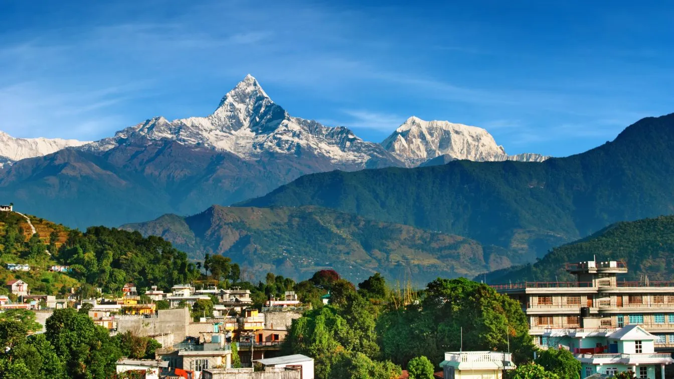
Drive from Tatopani to Pokhara
Description
The final mountain drive follows the Kali Gandaki River downstream through a landscape that softens gradually as the road descends. The terraced rice paddies, roadside fruit stalls, and warmer air are all gentle signals that you're re-entering the lower world. Pokhara appears in the afternoon, spread across the lakeside with the Annapurna range still visible in the background. After weeks of teahouses and trail food, Pokhara's restaurants, cafes, and creature comforts will feel genuinely wonderful. Tonight you sleep in a proper hotel bed, and the city's lakeside strip has no shortage of good food and cold drinks to mark the occasion. You've earned it.
Drive back to Kathmandu on a tourist bus
Description
The last morning. After breakfast in Pokhara, you board the tourist bus for the long drive back to Kathmandu (1,400 meters). The road follows the Marsyangdi and Trishuli Rivers through forested hills and riverside towns, and there's something quietly reflective about retracing this route now, after everything the past three weeks have held. Kathmandu arrives in the late afternoon, loud and full and familiar in the best way. You'll be dropped at your hotel, and the rest of the evening is yours. Whether that means a quiet dinner, a walk through Thamel, or just putting your feet up and doing nothing at all, you've more than earned the choice. Thank you for adventuring with us. We hope to see you back in these mountains again someday.
Accommodations
Accommodation during the Manaslu and Annapurna Trek is mainly in local teahouses and small mountain lodges scattered along the trail. In the Manaslu region, the lodges are generally simpler and more traditional, as this area is still less developed compared to other popular trekking routes. Rooms are usually basic with twin beds, mattresses, pillows, and blankets, providing a comfortable place to rest after a long day on the trail. The hospitality of the local hosts often makes the stay feel warm and welcoming, even in these remote mountain villages.
As the trek gradually connects with the Annapurna region, the accommodation becomes slightly more developed with a wider range of teahouses available in larger villages. Many lodges have cozy dining halls where trekkers gather in the evening to warm up, enjoy hot drinks, and share stories from the trail. Bathrooms are mostly shared, and hot showers may be available in some villages for an additional cost. Despite the simple facilities, the peaceful surroundings and the genuine friendliness of the local people make the overnight stays a memorable part of the journey.
Food
Food during the Manaslu and Annapurna Trek is simple, nourishing, and prepared fresh in the teahouses where you stay. The menus usually offer a mix of local Nepali dishes and a few international options that are suitable for trekkers. One of the most popular and recommended meals is the traditional Nepali dal bhat, served with rice, lentil soup, vegetables, and pickles. It is filling, healthy, and often comes with unlimited refills, making it a perfect meal for long trekking days.
Besides dal bhat, trekkers can also find dishes like noodles, fried rice, soups, pasta, pancakes, potatoes, and eggs in many teahouses along the route. Breakfast is usually simple but energizing, with options such as porridge, toast, eggs, and hot tea or coffee. While the meals may not be luxurious, enjoying a warm plate of food after hours of walking in the mountains often becomes one of the most satisfying moments of the day.
Trip Information
Seasonal Information:
The weather varies according to the season in the Annapurna region, which influences the experience of trekkers. During the spring season (March-May), the temperature is moderate, and you get to see clear skies with vibrant rhododendron blooms. You can see the clear mountain views with less snowfall in high passes. Likewise in the autumn season (September-November), which is the most popular for trekking, which offers stable weather and excellent visibility. Also the temperatures in the daytime are comfortable compared to night one. Due to dry weather, you can easily cross the passes. For the winter season (December-February), the region suffers cold temperatures, primarily at higher altitudes, and snow may cover some of the trails, which makes it more challenging for trekkers. Lastly, for Monsoon (June-August), rainfall can make trails slippery and risky. Despite that, the rich greenery gives a unique perspective to the region.
Cultural and Natural Insights:
From cultural aspects, the route passes through villages in the Manaslu region like Samagaon, Lho, and Samdo. You can see monasteries, prayer flags, and Mani walls, which are common along the route. In the Annapurna trail you can explore the culture of the Gurung, Magar, and Thakalis and their local foods and their warm hospitality. This circuit passes through villages like Pisang, Manang, and Muktinath. You can experience the spiritual energy in the Muktinath temple, which is a sacred place of Hindus and Buddhists. From natural aspects, the Manaslu Conservation Area is the home for species like snow leopards, Himalayan tahr, blue sheep, and unique alpine flora. Likewise, Annapurna offers you the diverse landscapes ranging from subtropical forest to arid high-altitude deserts. This trek offers the stunning views of mountains like Manaslu (8163 m), Annapurna (8091 m), Dhaulagiri (8167 m), and other Himalayas.
Sustainability and Responsibility:
The ecosystem of the Everest region has been significantly impacted by increasing tourism. Trekkers have some responsibilities towards the environment to preserve the beauty of the Himalayas for our own good and for the future generation. Here are some ways to practice environmental responsibility:
-
You can carry garbage bags with you or dispose of trash in designated areas.
-
Avoid using single-use plastic water bottles.
-
Choose accommodation that follows sustainable practice.
-
You can purchase local goods to uplift/support the local economy.
-
Avoid picking rare plants that take long to grow, and respect wildlife and their habitat.
-
Travel in groups to reduce ecological strain.
Modern Trekkers Expectations:
Now trekkers seek balance between adventure and the outside world while on a trek to be connected. Here are some expectations of modern travelers that we try to meet:
-
Internet access as Wi-Fi is available at Kagbeni, Jomson, and Muktinath.
-
Comfortable accommodation due to upgraded hygiene facilities.
-
Available expanded menu of options including pizza, pancakes, and vegetarian dishes.
-
You can enjoy Thakali sets, momos, and apple pies for food.
-
Sustainable and ethical practices, such as the sustainable practice of waste management and using renewable energy.
-
The trek is through remote valleys and high-altitude passes.
Why Choose Nepal Outdoor Expeditions?
At Nepal Outdoor Expeditions, we see trekking as more than just a hike; it’s a journey filled with unforgettable memories, cultural connection, and awe-inspiring scenery. Our dedicated team takes care of everything behind the scenes, ensuring your trip is seamless, safe, and deeply rewarding. Whether you’re new to the trails or returning for another Himalayan adventure, we’re here to turn your travel dreams into lasting experiences.
Treks That You Might Like:
Inclusions & Exclusions
✓ Included
- Airport pick-up and drop-off by private vehicle
- Government-certified guide
- Strong and helpful porter with proper equipment (1 porter for 2 people)
- Salary, food, accommodation, and insurance for guide and porter
- 1-night Hotel in Pokhara on a BB basis
- Tea house/lodge accommodation during the trek
- Standard meals (breakfast, lunch, and dinner) during the trek
- Fresh fruits every night after dinner
- All land transportation as per itinerary
- TIMS (Trekking Information Management System) card
- ACAP and MCAP entry permits
- Manaslu Restricted Area Permit
- Comprehensive first aid kit with oximeter to measure your oxygen level daily
- All government taxes and official expenses
- Duffel bag, sleeping bag, down jacket and walking poles for the trek
✗ Not Included
- International airfare and taxes
- Nepal entry visa fee
- Your Travel Insurance (compulsory)
- All the expenses of a personal nature
- Any kind of drinks and desserts during the trek
- Hotel in Kathmandu
- Tips to guide and porter (Tipping is expected)
JOIN OUR UPCOMING TRIPS
Everest Base Camp Trek 2026/2027
Annapurna Base Camp Trek
FAQs
The trek typically takes 20 days, as it covers both the Manaslu and Annapurna Conservation Areas.
The best time is in the spring and autumn seasons to do this trek.
Yes, you need permits like the Manaslu Restricted Area Permit, the Manaslu Conservation Area Permit, the Annapurna Conservation Area Permit, and the Trekkers’ Information Management System.
No, you cannot trek solo due to its long duration, and also hiring a guide would give you ethical experience.
On average the trek costs around $1500-$2000 per person.
Wi-Fi is provided by some tea houses at an extra cost. There is a network available in lower regions.
Yes, travel insurance is mandatory, and it covers your medical expenses and emergency helicopter evacuation.
ATMs are available in the city areas of Kathmandu and Pokhara. On the trek there is no ATM service, so you need to carry cash.