Some trekkers stare at the Everest Base Camp path and mutter, “Crowded.” You might be one. In which case, whispers of Kanchenjunga may have reached your ears. Hidden deep in Nepal’s east, near India and Sikkim, it offers trails where hours pass, whole days even, without spotting a single overseas hiker. Yet the big thing on everyone’s mind when getting ready shows up like an old friend: Is Kanchenjunga alone even possible?
Sure, traveling solo works fine. However, every hiker must now have an official guide. Rules changed in early 2023 when Nepali authorities required guided support for anyone trekking nationwide. That includes remote zones like Kanchenjunga, where oversight has always been tight. Imagine arriving with only boots, a map, and hope, you won’t get past the first checkpoint. Out here, walking alone toward Kanchenjunga, the air changes slowly.
Quick Facts About Kanchenjunga Trek
- Location: Eastern Nepal, near the border with India (Sikkim)
- Region: Kanchenjunga Conservation Area
- Highest Point: Pangpema (North Base Camp), 5,143 m
- Trek Duration: 17-28 days (depending on route)
- Difficulty Level: Challenging to strenuous
- Trek Type: Remote, off-the-beaten-path trekking
- Best Seasons: Spring (March-May) and Autumn (Sept-Nov)
- Maximum Altitude Risk: High (above 5,000 m); proper acclimatization required
Highlights of Kanchenjunga Trek
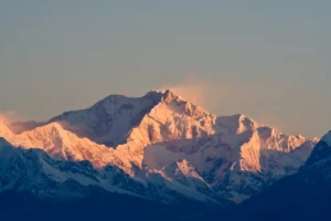
- The jewel of this trek is to stand at the base camp of the third-highest mountain in the world, Mount Kanchenjunga. You have the opportunity to gaze up at the huge mountain standing directly in front of you and the panorama of mountains that surrounds it.
- The views here are just incredible. The entire Kanchenjunga massif, with Kanchenjunga South and Kanchenjunga Central, and an entire series of other snow-white mountains running across the horizon, will be in view.
- Nature enthusiasts will be treated. Kanchenjunga is the home of certain unique and interesting species such as the snow leopard, red panda, blue sheep, and Himalayan tahr. Seeing even one of them in the wild is unforgettable.
- You can meet locals, learn their traditions, eat their food, and feel their hospitality as you explore traditional villages on the way. This is one of the aspects that makes the journey truly intimate.
- In comparison to most of the well-traveled trekking trails in Nepal, this trail is less visited. That translates to a lot more peace, a lot more quiet, and a lot more space to be able to take everything in without the crowds.
- The hike will bring you to several of the most beautiful glacial lakes at high altitude. Lampokhari Lake is a real highlight. It is serene, free, and seems to be untouched.
- It is difficult and rewarding to cross high-altitude passes such as the Margan La Pass. It is all worth it as soon as you observe the vast panorama of mountains and valleys stretched beneath you.
- On your way, you will also find some beautiful waterfalls, such as the great Jhapre Waterfall, a beautiful surprise hidden throughout the landscapes.
Why Kanchenjunga Draws Solo Adventurers in the First Place
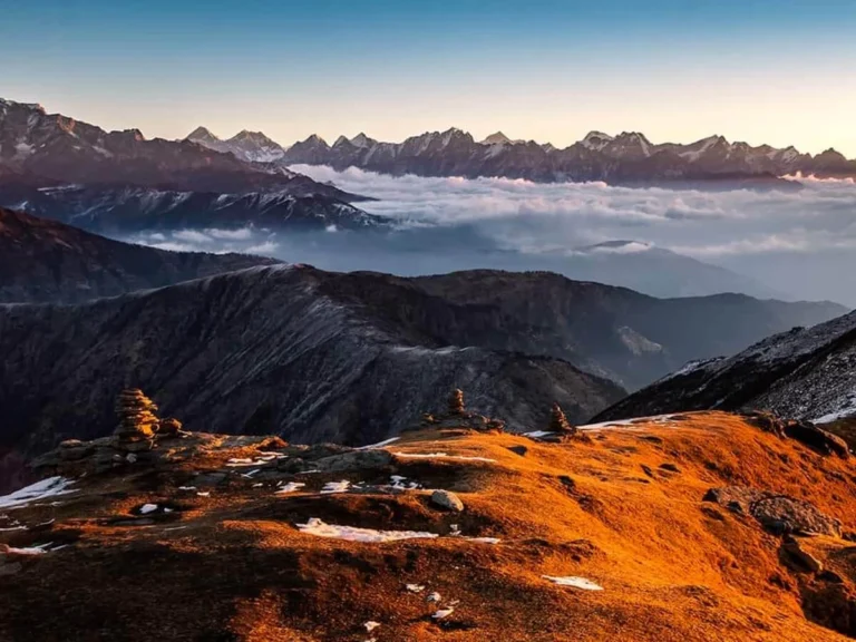
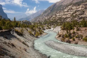
Kanchenjunga is the third-highest mountain in the world, standing at 8,586 meters. The climbing paths that lead to its base camps traverse some of the most pristine landscapes in the whole of Nepal.
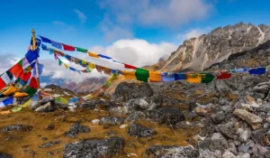
Unlike the Everest and Annapurna regions, where trekkers often share teahouse dining rooms with large groups every night, Kanchenjunga remains truly remote and isolated. The trails pass through villages such as Ghunsa, Khambachen, and Ramche. Sherpa and Limbu communities continue to live here while preserving their traditional way of life. Stone houses are decorated with prayer flags, and yaks graze beside glacial rivers. The rhythm of life feels untouched and far removed from the modern world.
It is that feeling of wilderness, pure and untamed, that makes solo trekkers come here. You are not simply strolling to a standpoint. You are immersed in weeks of real mountain trekking over a landscape that is not forgiving of mistakes.
The main route options include:
- Kanchenjunga North Base Camp Trek (Pangpema, 5,143 m): Typically 17-20 days. The route passes through Ghunsa to the northern base camp, offering spectacular views of the Kanchenjunga massif.
- Kanchenjunga South Base Camp Trek (Oktang, 4,730m): Around 15 days. A somewhat more direct path, via Yamphudin and Tortong, to the southern base camp.
- Kanchenjunga Circuit Trek: The complete adventure, with both base camps and crossing the high mountain passes such as Sele La (4,480 m), Sinion La (4,646 m), and Milgin La (4,645 m). This is a 24-28-day-long trek and is regarded as one of the most challenging long-distance treks in Nepal.
Detailed Itinerary
- Day 1: Fly to Bhadrapur and drive to Phidim: Your adventure kicks off the moment you leave Kathmandu. Our team will meet you at Tribhuvan International Airport and see you off on a short one-hour flight east. As the plane climbs, you get your first real glimpse of Nepal’s hilly terrain rolling out below you, a pretty good sign of what’s to come. Landing in Bhadrapur, you’ll hop into a vehicle for the drive up to Phidim. It’s a long stretch, around six to seven hours, but the highway runs through countryside that genuinely earns your attention. Phidim sits in a quiet valley deep in eastern Nepal, and on a clear day, the snow-covered peaks are visible from the viewpoints above town. By the time you check into your hotel or lodge, you’ll be ready for a proper rest.
- Day 2: Drive to Sekathum via Taplejung by jeep: Get an early breakfast because today is another long one. The drive from Phidim follows the Mechi Highway through Taplejung before continuing to Sekathum, and the scenery along the way makes the hours pass more easily than you’d expect. Taplejung itself is worth a brief stop. It’s an old settlement with deep Limbu roots, and the Pathibhara Devi Temple here draws pilgrims from across the region. After a short break to stretch your legs, you’ll continue to Sekathum, a small but welcoming village where you’ll spend the night.
- Day 3: Trek from Sekathum to Amjilosa: This is it, your first real day on foot. Step outside in the morning, and you’re already rewarded with a view of the Himalayas turning golden in the early light. After breakfast, you’ll lace up and head out. The trail starts gently, climbing past waterfalls and small streams before picking up pace toward Jabari, where you’ll stop for lunch. The afternoon section involves a steady climb, but the surrounding forest keeps things interesting. By the time Amjilosa comes into view, you’ll have earned your rest, and you’ll sleep well knowing the real journey has begun.
- Day 4: Trek from Amjilosa to Gyabla: Toda,y the trail follows the Ghunsa Khola river for much of the day, and it’s one of those walks where you lose track of time because there’s always something to look at. You’ll cross a bridge high above the river, push through patches of bamboo, and navigate a few switchbacks on rocky terrain. There’s one stretch that passes through a landslide-prone area, so you’ll move through it carefully and steadily. It’s nothing too dramatic, but it gives you a taste of the wilder side of this region. Gyabla is a small settlement, and you’ll find a comfortable spot to rest after what is a genuinely satisfying day of trekking.
- Day 5: Trek from Gyabla to Ghunsa: The trail narrows as you leave Gyabla, following the river through a valley that sits around 2700 meters. Rhododendrons and bamboo trees line much of the route, and if you’re lucky and quiet enough, you might spot red pandas or Himalayan black bears moving through the forest. After crossing through the winter settlement of Phale, the valley opens up, and Ghunsa comes into view, a proper mountain village ringed by snow-covered peaks. There’s a significant Sherpa community here, and you can feel the Tibetan Buddhist influence in the gompas, mani walls, and prayer flags that dot the village. Settle in, have a warm meal, and take it all in.
- Day 6: Acclimatization at Ghunsa: There’s no rushing today, and honestly, that’s a gift. Your body needs time to adjust to the altitude before pushing higher, so the day is yours to explore at a comfortable pace. A short hike up to the nearby ridges rewards you with a stunning view of Kumbhakarna Peak, more commonly known as Jannu, standing at 7,711 meters. The trail toward Lapsang La, following the Yamtari Khola, is another great option, with a glacial pond worth visiting along the way. Back in the village, take time to walk through the local lanes, observe daily life, and if you get the chance, try a cup of Tongba, the local millet wine. It’s warming in more ways than one.
- Day 7: Trek from Ghunsa to Khabhanchen: Leaving Ghunsa, the trail runs along the riverbanks through a beautiful forest of rhododendron, pine, and birch. It’s one of the more visually rewarding stretches of the entire trek, even as the terrain gets progressively more rugged. You’ll cross a wooden bridge to reach Rampuk Kharka, then navigate past cascading waterfalls before the trail enters a landslide zone where Mt. Jannu suddenly fills your field of vision from a completely new angle. It’s the kind of view that stops you mid-step. From there, ere it’s a solid push to Khambachen, where you’ll set up for the night.
- Day 8: Trek from Khambachen to Lhonak: A shorter day by distance, but you’ll feel the altitude doing its work. The landscape by now has shifted into high alpine territory: boulders, rocky hillsides, and very little vegetation to soften the views. The trail drops briefly before climbing alongside the river, crosses a bridge, and passes the beautiful Ramtang Monastery, a surprisingly serene spot in such a stark landscape. The visit to the gompa feels genuinely moving at this elevation. Lhonak is the last settlement before Kanchenjunga Base Camp, and there’s a quiet sense of anticipation in the air as you settle in for the night.
- Day 9: Trek from Lhonak to Kanchenjunga Base Camp, trek back to Lhonak: This is the day you’ve been building toward. The trail climbs gradually, moving through patches of wildflowers before the Kanchenjunga Glacier comes into view. You’ll need to cross it carefully, but the drama of the surroundings makes every careful step worthwhile. At the base camp, the world feels very big and very still. Mount Kanchenjunga towers above, and the surrounding peaks create one of the most awe-inspiring panoramas you’ll ever stand inside. Take your time here; take your photos; breathe it in. The descent back to Lhonak takes three to four hours, and by the time you’re back, the sense of accomplishment will feel very real.
- Day 10: Trek from Lhonak to Khambachen: Heading back down is a different experience from the climb. The same trail reveals new details when you’re moving in the opposite direction, and the yak pastures along the way seem more picturesque than they did heading up. The flora gets gradually richer as you lose elevation. It’s an easy, pleasant day, and Khambachen feels like a familiar friend by now.
- Day 11: Trek from Khambachen to Ghunsa: Today’s descent back to Ghunsa follows a trail you know well by now, and that familiarity is actually quite nice. The downhill path is forgiving on the legs, and you can afford to slow down and appreciate the views you may have moved past too quickly on the way up. Back in Ghunsa, enjoy a warm meal and a comfortable night’s rest before the trail takes a new direction tomorrow.
- Day 12: Trek from Ghunsa to Sele La Kharka: From Ghunsa, the trail turns south, and the landscape starts to shift again. The route to Sele La Kharka is one of the more varied days of the trek, passing through several different terrain types as you gain elevation. Snow-covered peaks stay in view for much of the walk, and the changing light throughout the day makes for some of the best photography of the entire circuit. It’s a long but deeply satisfying stretch.
- Day 13: Trek from Sele La Kharka to Tseram via Sinon La Pass: This is one of the most memorable days of the entire journey. You’ll cross not just one but two high mountain passes, Chele La and Sinon La, and the views from both are genuinely extraordinary. Standing at Sele La, you can pick out Mt. Kanchenjunga, Makalu, and several other giants on the horizon. Wildflowers appear alongside the trail in places you wouldn’t expect at this altitude, and wooden bridges lead you over clear mountain streams. The descent from Sele La drops around 1,000 meters, so your knees will feel it, but the scenery makes for a welcome distraction. Arriving at Tseram, you’ll feel the deep satisfaction that only a truly big day in the mountains can bring.
- Day 14: Trek from Tseram to Ramche: Leaving Tseram, the trail climbs gradually through beautiful alpine scenery before the terrain becomes more rugged. Lateral moraines appear alongside the route, evidence of glaciers that once shaped this entire valley. The village of Ramche is a small, quiet settlement with excellent views across the surrounding peaks. It’s the kind of place that feels genuinely remote, in the best possible way.
- Day 15: Trek from Ramche to Oktang Base Camp and trek down to Torangden: Another landmark day. The trail follows the alpine valley alongside the Yalung Glacier, crossing lateral moraines as the base camp draws closer. Oktang Base Camp sits at 4,730 meters, and Kanchenjunga’s southern face from this vantage point is nothing short of majestic. After spending time at the base camp and soaking in the views, you’ll begin descending toward the village settlement of Torangden. The three- to four-hour descent brings you back down through changing landscapes, and by the time you arrive, the evening light makes everything look even better than it already did.
- Day 16: Trek from Torangden to Yamphudin: The trail today follows the Simbuwa Khola river through the lower reaches of the Kanchenjunga Conservation Area, and the difference in vegetation compared to the high camps is striking. Rhododendrons, orchids, and other wildflowers line the path as you wind your way toward Yamphudin. Most of the day is a descent, and the rhythm of it is pleasant and easy after the demanding days higher up.
- Day 17: Trek from Yamphudin to Khebang: Starting early after breakfast, the trail climbs up through the settlement of Lamite Bhanjyang before dipping back down through dense pine forest. You’ll cross the Simbhua Khola and walk along the Amji Khola riverbanks before reaching a wooden bridge that signals you’re getting close. Khebang appears after six to seven hours of walking, a welcome sight after a day of varied terrain.
- Day 18: Trek from Khebang to Hapukhola: The last full day of trekking has a bittersweet feeling to it. The trail winds up and down through small settlements and lush hillsides, and there’s a temptation to slow down and make it last. The communities along the route offer a warm contrast to the remote high camps you’ve left behind. Hapukhola is a peaceful place to spend your final night on the trail.
- Day 19: Drive from Hapukhola to Bhadrapur: The trek is behind you, and the drive back to Bhadrapur rolls through farmland and village settlements that feel especially vivid after weeks in the mountains. It’s a good journey for quiet reflection, watching the landscape gradually flatten as you head toward the lowlands. Bhadrapur offers a comfortable place to rest before the final leg home.
- Day 20: Fly back to Kathmandu: The Kanchenjunga Circuit Trek draws to a close as you board your flight back to Kathmandu. One hour in the air, and you’re back in the city. The mountains, the passes, the monasteries, and the long days on foot stay with you long after the trek ends.
Can You Do the Kanchenjunga Trek Solo? The Legal Reality
We will get this straightened out.
As of April 3, 2023, solo climbing without a licensed guide has been prohibited in Nepal. The Nepal Tourism Board came up with this regulation due to major safety reasons and to provide a larger number of jobs to the local communities. Kanchenjunga has been an area of restricted access since before this rule was put in place, so the necessity of a guide in this area was not optional to start with.
But what is the meaning of solo here?
It will allow you to tour without a crowd, without other vacationers, and at your own speed. In that respect, you are a lone traveler. However, a licensed agency will have to employ a registered trekking guide. Your guide will be in charge of logistics, navigating the difficult parts of the trail, interacting with the local communities, and supporting any crises.
Some trekkers feel frustrated by this rule. Yet, to be frank, in a place so remote as Kanchenjunga, an experienced guide is not a mere bureaucratic necessity. It is essential. There is barely any cell coverage on a large portion of the trail. Days are required in an emergency rescue. Getting lost in places over 4,000 meters during bad weather and being on your own is not the place you want to be.
It is not a legal thing to hire a porter,rter but highly suggested on the basis of the distance to be covered in the trek and the weight you are going to carry. The majority of solo trekkers are left with a single guide and a single porter.
How to Get to the Kanchenjunga Starting Point
The trek usually commences from Taplejung or Sekathum, depending on your itinerary. There are mainly two ways from Kathmandu to Taplejung:
- By air: Take a flight from Kathmandu to Bhadrapur (the nearest airport, about 1 hour) and thereafter travel by jeep from Bhadrapur to Taplejung. The jeep journey takes about 5-6 hours along winding mountain roads. This is the fastest option overall.
- By road: Some trekkers choose the overland route, which consists of a long bus or jeep journey of around 16 to 18 hours from Kathmandu. It is exhausting, but you get to see the landscape thoroughly even before the trek starts. Usually, the trail for the northern circuit after Taplejung goes towards Sekathum and then Ghunsa. The southern route is for Yamphudin.
Best Time for the Kanchenjunga Trek Solo
The Kanchenjunga region shares the weather patterns similar to the rest of Nepal, yet it is remote, so poor weather conditions feel much more serious here than on more popular trails.
- Spring (March to May): One of the most popular trekking seasons. The rhododendron woods are in flower, especially at lower altitudes. The weather is usually clear in the mornings, and it is cold at higher altitudes, but bearable. The first half of May and the month of April are generally regarded as the sweet spot.
- Autumn (end of September to November): The air in the post-monsoon is normally crystal clear, and that implies breathtaking mountain views. October is very favorable for visibility. The temperatures begin to drop in November, and towards the end of November, snow is able to fall on the higher passes.
- Monsoon (June to August): It is extremely difficult with heavy rainfall, trails that are full of leeches, mudslides, and flooded rivers. The majority of seasoned trekkers shun Kanchenjunga when it is in monsoon.
- Winter (December to February): Snow may block the high mountain routes, and the temperatures in high altitudes drop to very low levels. This is only attempted in winter by very seasoned cold-weather trekkers.
|
Season |
Months | Trail Conditions | Recommended? |
|
Spring |
March to May |
Clear mornings, rhododendrons in bloom, manageable cold at altitude |
Yes, April is the sweet spot |
| Autumn |
Late September to November |
Post-monsoon clarity, excellent mountain views, dropping temps by November |
Yes, October is ideal |
| Monsoon | June to August | Heavy rain, landslides, leeches, flooded rivers |
No |
| Winter |
December to February |
High passes blocked by snow, extreme cold at altitude |
Only for very experienced cold-weather trekkers |
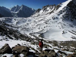
The Trail: What Solo Trekkers Actually Experience
Among these is the fact that the Kanchenjunga trek is not like the Annapurna Circuit because the scenery is different as you ascend the mountain.
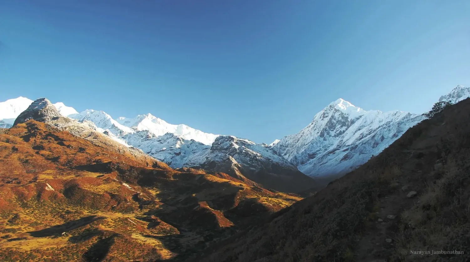
You begin in a subtropical jungle at lower altitudes, where you could get to hear hornbills and even see red pandas if you are lucky. The forest then changes to oak and rhododendron. Further up, you enter a juniper and rocky alpine landscape to arrive at the glacial moraines in the base camp.
The Kanchenjunga Conservation Area is a place where snow leopards, Himalayan black bears, musk deer, blue sheep, and over 250 bird species can be found. Sightings of snow leopards are extremely rare, but the fact that they exist adds to the silence of the high country.
The physical difficulty is a reality. Days are lengthy, in most cases, 6-8 hours of walking with a lot of elevation. The landscape features tiny ridge tracks, suspension bridges across booming rivers, areas with landslides, and rocky switchbacks. The circuit route is on high passes, and so it requires early starts and fitness.
- Accommodation: Teahouses are on the main trail, but they are simpler and more basic as you rise in altitude. In smaller towns such as Taplejung and Chirwa, there are moderately comfortable rooms with their own bathroom and hot shower. At higher camps such as Ghunsa and Khambachen, there will be shared toilets and no hot water. Carry a good sleeping bag that has at least a -10°C rating.
- Food: The ubiquitous meal is dal bhat (the typical Nepali rice and lentil dish). In lower altitudes, teahouses are also used to serve noodles, eggs, fried rice, and occasionally pasta. Further up, the menu becomes reduced. Always bring energy bars, nuts, and chocolate to add to your meals on more walking days.
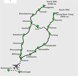
How is the Kanchenjunga Circuit Trek map helpful for guides and trekkers throughout the journey?
A Kanchenjunga Circuit Trek map is a basic yet very handy tool which assists not only guides but also assists trekkers to have a clear picture of the whole path. It depicts the main route, major towns, crossroads, and major points of interest along the route. By having the map available both prior to and throughout the trek, it is easier to see where you are going on a given day. This makes the travelling less chaotic and disoriented, particularly in such a remote area.
The map can also be used to conceptualize distances, changes in elevation, and the route structure in general. This is because you can view how the trail leads out of one location to another with the North Base Camp part as well as the South Base Camp part. This establishes more confidence in the trekkers and makes them psychologically ready to experience long walking days and altitudes.
Nevertheless, even with a detailed map, it is highly important to have an experienced guide. The Kanchenjunga is home to numerous isolated trails, and circumstances might alter due to weather or landslides. A guide is familiar with the local routes and can modify the plan as required, which a map can never achieve.
A good and accurate trekking map can help you stay on schedule, spend less time, and enjoy the walk without any undue pressure. It is also a plus in that it gives you a feeling of security and consciousness as you transit various sceneries. These are the reasons why a good Kanchenjunga Circuit Trek map is an inalienable companion in this adventure.
Useful Information
Altitude Sickness: What Solo Trekkers Need to Take Seriously
The Kanchenjunga Circuit reaches over 5,000 meters at the northern base camp, and the high passes on the circuit path are 4,500-4,700 meters. The possibility of altitude sickness is real.
The principle of acclimatization applies here, just as it does throughout the Himalayas. Ascend gradually and avoid pushing yourself too hard. Stay hydrated at all times, and be prepared to descend if you experience severe altitude sickness symptoms.
The typical symptoms of acute mountain sickness (AMS) are a headache, nausea, fatigue, and dizziness. More severe ones are High Altitude Pulmonary Edema (HAPE) and High Altitude Cerebral Edema (HACE), which necessitate descent and can cause death in case of neglect.
Your guide should be trained to recognize altitude sickness symptoms. This is among the strongest reasons why a seasoned guide should guide one on an isolated pathway such as Kanchenjunga. Something can go wrong above 4,000 meters, and there is no one around, and the consequences can be dire.
Diamox (acetazolamide) is the common preventive taken by many trekkers. Before your trip, consult a doctor about whether this is suitable for you.
Permits You Need for the Kanchenjunga Trek
Getting this detail correct matters more than most realize. Three distinct permits are needed for Kanchenjunga, each mandatory before beginning.
- Kanchenjunga Restricted Area Permit (KRAP): The Kanchenjunga Restricted Area Permit (KRAP) costs around USD 20 per person per week during peak seasons (March-May and September-November). It requires a minimum of two trekkers, though solo travelers usually meet this requirement by hiring a guide.
- Kanchenjunga Conservation Area Permit (KCAP): Getting inside the Kanchenjunga Conservation Area means paying a charge. Right now, that’s about NPR 3,000, which works out to close to USD 22 to 24. From time to time, small shifts happen in the exact dollar value.
- TIMS Card: Trekkers’ Information Management System. A basic pass covers nearly every hiking zone across Nepal. Around 10 to 20 U.S. dollars change hands, depending on whether a middleman handles it or you do it alone. Before heading out from Kathmandu, get every permit sorted first. Your trekking company, with a proper license, takes care of all documents. Checkpoints on the route won’t let you pass unless a guide is with you and permits are ready.
|
Permit |
Issued By | Approx. Cost | Notes |
|
Kanchenjunga Restricted Area Permit (KRAP) |
Department of Immigration | USD 20/person/week (peak season) | Requires a minimum of 2 people; solo trekkers usually count their guide as the second person |
| Kanchenjunga Conservation Area Permit (KCAP) | Det of National Parks and Wildlife Conservation | NPR 3,000 (approx. USD 22 to 25) |
Covers entry into the conservation area |
| TIMS Card | Nepal Tourism Board | USD 10 to 20 |
A standard permit is required across most of Nepal’s trekking regions |
Travel Insurance for Solo Trekkers
Do not skip this. The Kanchenjunga trek travel insurance is not optional in any practical sense.
A policy that clearly addresses the following:
- Trekking at altitudes above 5,000 meters.
- Helicopter evacuation (this is the critical one)
- Emergency medical treatment
- Delays and cancellations of trips.
There are very limited medical facilities in the Kanchenjunga region. Helicopter evacuation will be needed to evacuate a seriously injured or ill person, costing USD 3,000 to USD 10,000 or more, depending on the area. In the absence of insurance, you cover that out of pocket.
Read the fine print. Other generic travel policies prohibit high-altitude activities or limit the helicopter evacuation coverage to too low an amount. Search for policies offered by companies that cover Himalayan trekking in particular.
Choosing the Right Guide and Agency
There is a need to hire a guide, so it is important to get this right. Some items to consider:
- Check agency registration: Your trekking agency is to be registered by the Nepal Tourism Board (NTB) and the Association of Trekking Agencies of Nepal (TAAN). It is not mere officiality. It makes sure that your money is going through the right channels and that your guide has been trained.
- Inquire of your guide about his or her experience with Kanchenjunga: A guide who has led the Annapurna Circuit several times is not the guide who has led the Kanchenjunga region on numerous occasions. The long paths, the native language, and the special barriers demand knowledge.
- Read online reviews: Find online reviews on websites such as TripAdvisor, Google, or trekking forums. What solo trekkers of the past say in particular.
- Video call before booking: This will give you an idea of how well the guide communicates and what kind of personality they have. You will be spending weeks together with this person.
- Allocate reasonable wages: Trekking guides in the Kanchenjunga area normally receive USD 25-35 per day. Porters earn USD 18 to 25. These are physically challenging, skilled works in an isolated setting. Rewarding employees well is morally right, and it is in your best interest because employees who are well-rewarded are driven and trustworthy.
Solo vs. Group: Which Is Better for Kanchenjunga?
They both have their advantages, and the correct one will require your personality and experience.
Going alone (with a guide) would mean you move at your pace, take breaks when you feel like it, and have a truly personal experience with your guide and the communities you pass. Something about a mountain trip that proceeds at your own pace is very gratifying.
Hiking with a few people is another energy. The expenses are distributed, and this may make the adventure less expensive. In case a person experiences altitude sickness or an injury, there are more people who will assist. The social aspect of group trekking may be gratifying, particularly during long evenings in teahouses.
To the truly solo-minded trekkers, the most popular way of going the Kanchenjunga route is to hire a guide through an agency and trek in pairs (with your only guide). Their guide is one of the most memorable aspects of the whole expedition for many.
Packing Essentials for the Kanchenjunga Solo Trek
The distance of the pathway ensures that you cannot readily buy spare equipment that you have forgotten. The following is what the seasoned Kanchenjunga climbers will always suggest:
- Dressing and coziness: All that. An excellent down jacket, thermal base clothing, a fleece mid-layer, a waterproof shell jacket and pants, wool hiking socks, and a warm hat and gloves that can withstand freezing temperatures are essential. On the steep descents, the use of trekking poles comes in handy.
- Sleeping bag: A sleeping bag that is -10 to -15 °C is significant in higher camps, particularly in October and the early spring.
- Navigation and safety: A GPS (Gaia GPS and Maps.me are both offline in Nepal), a headlamp with spare batteries, a basic first aid kit (with blister treatment), or a personal locator beacon (PLB) in case you want an added safety measure.
- Money: There are no ATMs along the trail. Bring enough Nepali rupees in cash to pay for all your expenses for the whole journey. The amount will be recommended by your guide or agency, but you should budget higher than you imagine you will require.
Conclusion
A solo Kanchenjunga trek is one of the most rewarding options to offer to the trekkers in Nepal. The scenery is beyond magnificent, the culture is true, and the feeling of not being on the well-trodden path lingers in your mind long after you have gone back to Kathmandu.
The compulsory guide rule is no obstacle. Consider it a necessity that is also convenient to make your walk more secure, meaningful, and manageable. The exemplary guide does not simply show the way. They interpret, introduce you to the locals, point out to you wildlife you would otherwise miss, and possess the wisdom of a region that it takes years to get to know how to interpret properly.
Think before you leap, choose the correct season, have your permits in place, and make sure that the agency you go to has some idea of the Kanchenjunga region. To get going, the team at Nepal Outdoor Expeditions has assisted the solo trekkers in planning this specific route and can answer the practical questions that you cannot easily find the answers to on the Internet. The remainder is but a foot ahead of the other, over some of the most beautiful country on earth.
Explore Our Other Related Article:
Kanchenjunga Circuit Trek Cost
FAQs
1. Is the Kanchenjunga trek suitable for beginners?
Honestly, not really. It is more challenging than most treks in Nepal, both in terms of length and elevation. You will walk many hours a day in remote locations with minimal amenities and will stay above 4,000 meters for several nights. It is better suited to trekkers who already have some experience with high-altitude, multi-day trekking.
2. How much does the Kanchenjunga trek cost for a solo traveler?
For a solo traveler, the cost is approximately USD 1,800 to USD 3,500. It depends on your itinerary, the number of days, and the level of service you choose. As you cannot walk entirely alone in this area, you will need to go through a registered agency and hire a guide, which increases the price. Some of the costs involved are permits, guide and porter fees, accommodation, meals, and transportation, such as flights to Bhadrapur. It may seem costly, but the trek is remote and logistically complex, so the price is not bad.
3. Do I really need a guide, or can I arrange permits independently?
You do need a guide, and you cannot arrange all the permits by yourself. Kanchenjunga is a restricted area, and the primary permit can only be issued by a registered trekking agency. To add to that, a licensed guide is a requirement now. Most trekkers would also opt to have a guide with them despite the absence of the rule due to the remoteness of the trail. There are sections where signage and network coverage are very limited, and villages are far apart. A guide makes it easier to manage logistics, stay on track, and handle unexpected situations on the way.
4. How long does the Kanchenjunga trek take?
The distance of the walk will vary according to the path you take. The North Base Camp trek typically takes between 17 and 21 days. In comparison, the South Base Camp trek is slightly shorter and usually takes between 14 and 16 days. If you choose the full circuit, including both base camps and high mountain passes, the trek can take between 24 and 28 days. Some trekkers also add extra days for acclimatization. Weather conditions may also cause delays, so adding a few buffer days to your itinerary is always a good idea.
5. What happens if I get altitude sickness on the trail?
One thing you should be aware of on this trek is altitude sickness. Your body takes time to adapt as you climb higher, particularly beyond 4,000 meters. The initial symptoms may be headache, nausea, dizziness, and loss of appetite. Your guide will tend to monitor your day-to-day well-being. When symptoms appear, taking a rest and waiting to see whether they improve is the first step. When they become worse, the most suitable measure is to go down to a lower altitude. A helicopter evacuation might be necessary in more severe cases. This is precisely the reason why it is very important to have the right travel insurance that will cover high-altitude trekking and evacuation before embarking on the trek.
6. What kind of accommodation and food can I expect on the trek?
Teahouses on the Kanchenjunga trail are quite basic, particularly as compared to other more frequently used trekking trails. In lower villages, you may be able to get somewhat comfortable rooms, sometimes with attached bathrooms. The higher you go, the more basic it becomes. Most places have small rooms, communal toilets, and no heating. Food is plain but nutritious. The most common meal is dal bhat, along with noodles, soups, eggs, and fried rice. The higher you climb, the fewer choices you are going to have, so it is always a good idea to bring snacks with you, such as energy bars or nuts, to get additional energy on long days.
7. Is internet, electricity, or a mobile network available during the trek?
You cannot count on good connectivity on this trek. In the lower areas, such as Taplejung, you may get mobile network coverage and intermittent internet access. However, as you move to higher elevations, the network becomes weak or disappears completely. There are villages where Wi-Fi is available, but it is often slow and unreliable. Electricity is available in most locations, and much of it is generated through solar power. However, you may need to pay an additional fee to charge your devices. It is best to expect limited connectivity and spend most of the trek offline. Carrying one or two power banks is recommended to keep your devices charged.