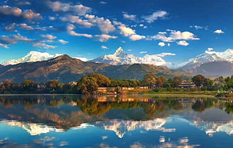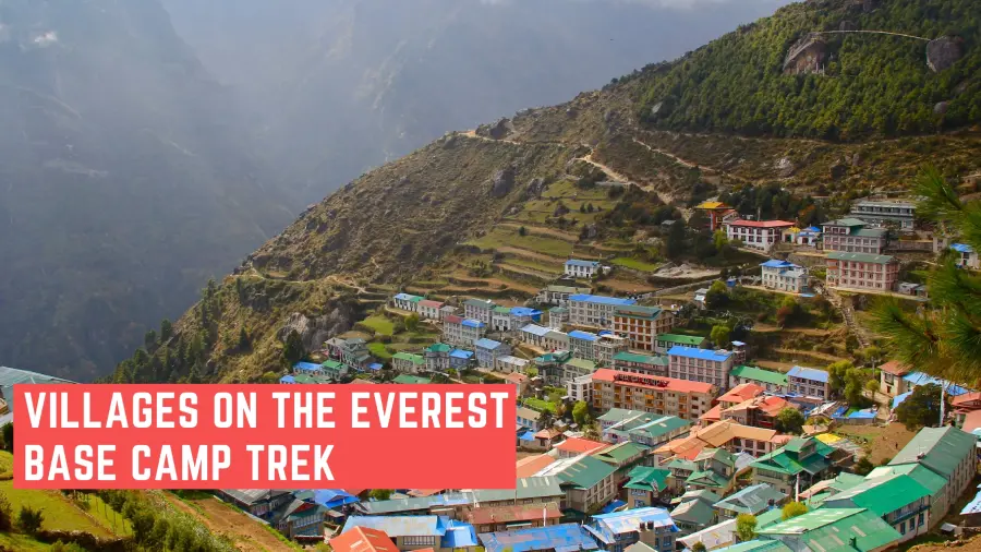
The Everest Base Camp trek is, at its core, a walk between villages. The mountain is the destination; however, the villages are what make the journey memorable. Each one sits at a specific elevation, serves a particular purpose on the route, and has its own character, from Lukla’s chaotic little high avenue to the handful of stone resorts at Gorak Shep, where the teahouse owner is aware of exactly why you cannot sleep.
The route follows the Dudh Koshi valley northward through Sagarmatha National Park, gaining altitude progressively from Lukla’s airstrip at 2,860m to the remaining permanent settlement at Gorak Shep at 5,164m. Fifteen villages. Roughly 12-14 days of taking walks. This guide explores them in trekking order, so it really works both as an adventure for first-timers and as a path reference whilst you’re planning your trek and need to understand what is certainly ready at the end of each day.
The Quick Route: Every Village in Order
Here are all settlements on the standard EBC route, in order, with elevations. Save this or screenshot it; it’s the clearest answer to “what does the route actually look like?”
| Village | Elevation | Role on the Trek |
| Lukla | 2,860m | Trek start, fly in/out |
| Chheplung | 2,700m | Brief early stop |
| Phakding | 2,610m | Standard first overnight |
| Monjo | 2,835m | National Park entry checkpoint |
| Jorsale | 2,740m | Pre-Namche last flat stretch |
| Namche Bazaar | 3,440m | Main hub, first acclimatization stop |
| Khumjung | 3,790m | Side trip from Namche |
| Kyangjuma | 3,550m | Small stop en route to Tengboche |
| Tengboche | 3,860m | Monastery village, a spiritual landmark |
| Deboche | 3,820m | Quiet stop just below Tengboche |
| Pangboche | 3,985m | Oldest monastery, underrated stop |
| Dingboche | 4,410m | Acclimatization stop (eastern branch) |
| Pheriche | 4,371m | Acclimatization stop (western branch) |
| Lobuche | 4,940m | Last staging point before the end |
| Gorak Shep | 5,164m | Final settlement, base for EBC and Kala Patthar |
One issue most guides get wrong: Dingboche and Pheriche aren’t on every itinerary. They sit down on parallel branches in the same direction. Most trekkers undergo one or the other, not both. Your itinerary will specify which department you’re in.
Lukla: Where the Trek (and the Nerves) Begin
Elevation: 2,860m. Role: Trek start and finish point.
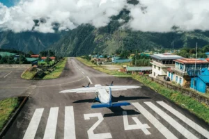
Tenzing-Hillary Airport in Lukla has a 527-meter runway that ends at a wall. Flights in from Kathmandu take approximately 35 mins and land on a slope. It’s worth understanding this because the airport’s reputation is often exaggerated. Thousands of trekkers fly in and out every season without incident. The nerves are real, but they’re attainable.
The village itself is a single, foremost street lined with gear stores, bakeries, and lodges. If you want a closing-minute buff, a warmer layer, or only a warm tea before you start walking, it’s all here. Prices are slightly better than Kathmandu but reasonable as compared to what you will pay better up.
Most trekkers spend less than an hour in Lukla on day one. You land, kind your baggage, eat something, and begin on foot closer to Phakding. The village makes a very distinct impact on the return journey: after two weeks at altitude, the same bakery smells better, the beer tastes better, and the runway seems almost pleasant.
Lukla is also where you’ll want your trekking permits looked after before you move. Make sure you have the Sagarmatha National Park Permit and the Khumbu Pasang Lhamu Rural Municipality Permit before starting the trek.
Phakding: The Easy First Night
Elevation: 2,610m. Role: Standard first overnight stop.
Phakding sits decrease than Lukla, that is certainly a factor. The path drops gently from the airstrip and follows the Dudh Koshi River south, before turning north once more, giving your frame a mild introduction to path walking with no extreme elevation gain on day one.
The village runs along the riverbank. You’ll cross your first suspension bridges right here, the kind strung with prayer flags that clap inside the wind above turquoise glacial water. If you’ve never walked a Himalayan suspension bridge before, Phakding is a superb area to get snug with them. There are larger ones ahead.
Teahouses here are a few of the most snug on the path: private rooms, reliable hot showers, and menus that still stretch to pizza and pasta along the dal bhat. Enjoy it. The more you pass, the less complicated the lodges get.
Phakding does not ask a great deal of you, and that’s exactly what it is for. Eat well, sleep early, and let the sound of the Dudh Koshi help you relax. Tomorrow’s stroll to Namche Bazaar is the primary absolutely worrying day on the trek, finishing with a steep 600-meter climb to the Khumbu’s main hub.
Monjo and Jorsale: The Gateway Villages
Monjo elevation: 2,835m. Jorsale elevation: 2,740m. Role: National Park entry and pre-Namche staging.
Monjo is where the Khumbu formally starts off. The Sagarmatha National Park checkpoint sits right here, and each trekker stops to get an allowance stamped before continuing. Have your documents equipped and on hand; the queue can back up throughout the height of the season. If you haven’t taken care of your permits before arriving, this is when that oversight turns into trouble. Our Nepal trekking permits guide covers precisely what you want and where to get it.
Beyond the checkpoint, the trail drops to Jorsale, a small cluster of accommodations wedged between the river and the forest. Some trekkers stop right here for lunch; however, they push through. Jorsale’s most important position is practical: it’s the closing flat ground before the trail begins hiking significantly closer to Namche Bazaar.
Between Jorsale and Namche, you may go to the famous Hillary Suspension Bridge, one of the longest suspension bridges in the vicinity, strung above a deep river gorge with Everest in short sight through the valley if conditions are clear. Then the climb starts. Around six hundred meters of steep, relentless ascent through pine and rhododendron forest, the kind of climb that slows each person down, no matter their fitness stage.
Monjo and Jorsale are functional rather than memorable. They exist to move you through, and they do this job properly.
Namche Bazaar: The Capital of the Khumbu
Elevation: 3,440m. Role: Main trek hub and first major acclimatization stop.
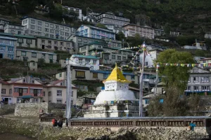
Namche Bazaar is where the trek changes dramatically. Until now, the direction has felt like a heat-up. Namche seems like a place.
The metropolis is constructed into a natural amphitheater on the hillside, rows of inns, eating places, and shops stacked above each other in a horseshoe form, with the valley lying away beneath and the white peak of Kongde growing behind. On a clear morning, you may see Everest over the ridge to the north. Most trekkers aren’t aware of it the first time because they’re too busy locating their inn.
Standard itineraries include two nights here, and the reasoning is simple: you have climbed from around 2,600m to 3,440m in days, and your body needs time to adjust before going higher. A rest day in Namche is not wasted time. It’s the cause you’re making it to Base Camp without turning back early. For an in-depth breakdown of why acclimatization topics are an awful lot, our manual on altitude sickness on Nepal treks is worth reading before you depart from home.
What’s Actually in Namche
This is the element that surprises most first-time trekkers. Namche has bakeries producing proper sourdough and cinnamon rolls. It has equipment shops stocked with North Face, Arc’teryx, and each Nepali-made opportunity, an espresso store with a coffee system, and an Irish pub at 3,440 meters above sea level. At the proper time, this place also has a crowd to fill it.
The Saturday marketplace is well worth timing your itinerary around if feasible. Local Sherpa and Tibetan traders carry produce, dried items, and yak wool gadgets down from surrounding villages. It’s one of the few places on the trek where the industrial activity feels surely rooted in the area rather than built for trekkers.
The Sherpa Culture Museum sits simply above the main bazaar place and covers the history of Khumbu’s Sherpa communities, their relationship with the mountains, and the transformation the hiking industry introduced to the region. It’s a good acclimatization-day prevent and takes about an hour.
Side Trip: Khumjung and the Hillary School
A 40-minute stroll above Namche, Khumjung sits at 3,790m and appears like a one-of-a-kind international village. Quieter, older, less visited. Sir Edmund Hillary founded the faculty right here in 1961, and it still operates nowadays. The Khumjung Monastery is one of the oldest within the region and reportedly houses a yeti scalp, which the clergymen will display to you if you ask.
Khumjung is the excellent answer to the question “Is there anywhere on this trek that is not full of trekkers?” There isn’t always, but Khumjung comes close. It’s a smooth half-day from Namche and doubles as beneficial acclimatization, taking walks.
Tengboche: The Spiritual Heart of the Trail
Elevation: 3,860m. Role: Monastery village and the single most dramatic viewpoint on the trek.
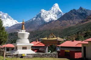
The approach to Tengboche earns its recognition. The trail drops from Namche into the Dudh Koshi valley, crosses a suspension bridge at Phunki Tenga, then climbs steeply via a rhododendron-wooded area that, in spring, blooms purple and crimson all the way up to the ridge. When the woodland opens at the pinnacle, Tengboche Monastery appears in front of you with Ama Dablam growing behind it in a close-to-perfect triangle of rock and ice. It’s the type of view that stops conversations mid-sentence.
Tengboche Monastery is the largest within the Khumbu region. Founded in 1916 and rebuilt after a 1934 earthquake and a 1989 fire, it remains the spiritual center of Sherpa Buddhist lifestyles in the location. The primary courtyard faces immediately closer to Everest, Lhotse, and Nuptse to the north and Ama Dablam to the southeast. Trekkers can enter the monastery itself; remove your shoes, remain quiet, and avoid photographing the interior without permission.
If your itinerary puts you in Tengboche in the late afternoon, take a look at whether a prayer ceremony is scheduled. The sound of the horns and drums wafting throughout the courtyard as the light drops off the peaks is the type of precise, unrepeatable tour second that this trek sometimes produces.
Deboche, a fifteen-minute walk under Tengboche, gives a quieter overnight alternative with a small nunnery and noticeably fewer trekkers. Some guides decide upon it for exactly that reason.
Pangboche and Deboche: The Quiet Middle
Pangboche elevation: 3,985m. Role: Ancient monastery village and underrated overnight stop.
Pangboche doesn’t receive the attention it deserves. Most trekkers skip through to Dingboche, stop for lunch, and keep shifting. The ones who stay overnight tend to want what they had regarded about it in advance.
The village splits into upper and lower sections. Upper Pangboche holds the oldest monastery in the Khumbu region, believed to have been founded by the Buddhist saint Lama Sange Dorje in the late seventeenth century. Unlike Tengboche, which was rebuilt twice after disasters, Pangboche’s monastery retains tons of its authentic structure. The juniper trees in the courtyard are said to have grown from the saint’s hair. Whether or not you interact with that as history or legend, the location has a stillness that Tengboche, with its constant movement of trekkers, does not always control.
The views from upper Pangboche are some of the best in the entire direction for Ama Dablam. You’re near sufficient now that the mountain fills a significant part of the sky to the south, and the perspective from the village is purer than from Tengboche.
The surrounding location also marks a clean shift inside the landscape. The ultimate of the massive trees out around here. The terrain starts establishing itself in wider, rockier valley perspectives. You’re getting into the excessive Khumbu right, and the villages from this factor on mirror that: smaller, more uncovered, built for feature over comfort.
For trekkers asking which village on the EBC direction feels least industrialized, Pangboche is the honest solution.
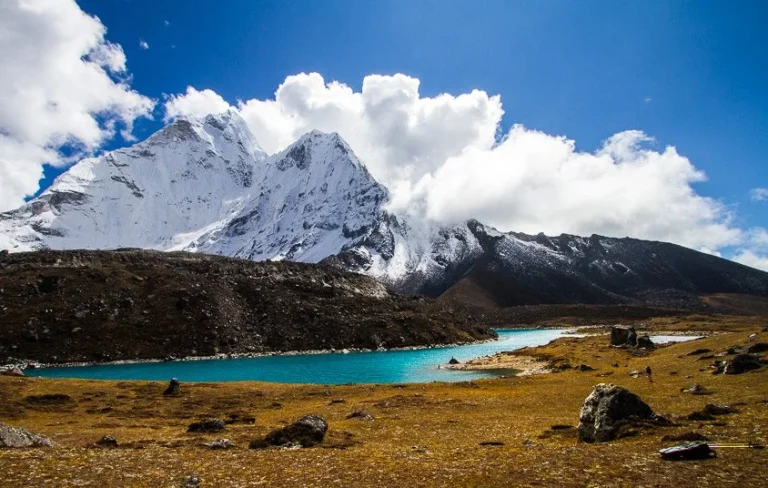
Dingboche and Pheriche: Where the Air Gets Thin
Dingboche elevation: 4,410m. Pheriche elevation: 4,371m. Role: Second major acclimatization stop.
This is when the trek is extreme for most people’s bodies, irrespective of how healthy they are. There is a significant elevation gain between Pangboche and Dingboche/Pheriche. The tree line is gone. The valley widens right into an extensive, stone-walled highland that Sherpa farmers traditionally used for summertime grazing. The wind picks up. The air is especially thin.
As stated inside the route desk, Dingboche and Pheriche aren’t the same stop on the same trail. They sit on parallel branches:
- Dingboche lies up the Imja Khola valley to the east, and most modern-day itineraries pass via here.
- Pheriche sits within the principal Khumbu valley to the west, at the older, more direct line to Lobuche.
Your itinerary will path you via one, not both. If you’re on the Everest Base Camp trek with a well-known acclimatization timetable, it is most probably Dingboche.
Acclimatization Day at Dingboche
The fashionable acclimatization hike from Dingboche goes as high as Nagarjun Hill at around 5,100m. It’s a steep, rewarding climb that offers you an actual preview of what high-altitude on foot looks like before you decide to make the final push. The views across to Island Peak, Makalu, and the Amphu Labtsa are really worth each meter of the ascent.
This is likewise the degree to which a few trekkers first observe real altitude symptoms: disrupted sleep, reduced appetite, mild headache. None of those are motives to panic; however, all of them are reasons to pay attention. Don’t push through signs and symptoms right here. The quality rule on any high-altitude trek is easy: if you feel worse at rest, pass down. Our guide on altitude sickness on Nepal treks covers the cautionary symptoms in detail and is really worth revisiting at this point in the trek.
Pheriche has a Himalayan Rescue Association useful resource put up that runs altitude sickness briefings every night during the hiking season. If your route takes you through Pheriche, attend it. The docs stationed there have seen every version of altitude-related hassle and supply sensible, direct advice.
Lobuche: The Last Real Stop Before the End
Elevation: 4,940m. Role: Staging point for the final push to Gorak Shep and Base Camp.
Lobuche isn’t always a charming village. It’s worth noting that some guides seem to oversell it. It’s a narrow collection of stone teahouses wedged into the lateral moraine of the Khumbu Glacier, purposeful and exposed, with cold nights and simple facilities. The accommodations here are among the most spartan on the route: shared rooms are not unusual, warm showers are unreliable, and the menu shrinks incredibly compared to lower stops.
None of that matters a whole lot, because by the time you attain Lobuche, you’re near enough to Base Camp that the village’s consolation stage becomes almost irrelevant. Trekkers arrive, devour, sleep as well as the altitude allows, and depart early the subsequent morning.
What Lobuche does offer is proximity to two matters well worth knowing about. The Khumbu Glacier’s lateral moraine runs directly along the path coming near the village, and the size of it, a huge, sluggish-transferring river of ice and rock, starts to give you an experience of the geological forces at work right here. Just above the village, a small memorial website online holds stone monuments to climbers and Sherpas who’ve died on Everest and the encompassing peaks. It’s a sobering thought that many trekkers go to sleep quietly earlier than continuing.
The Pyramid International Laboratory, a high-altitude research station run by a consortium of Italian medical institutions, sits approximately an hour above Lobuche. It’s now not open to trekkers but is visible from the path.
Pack your warmest layers on hand for the Lobuche night. Temperatures frequently drop well beneath freezing, and the walk to Gorak Shep the subsequent morning starts cold.
Gorak Shep: The Final Settlement
Elevation: 5,164m. Role: Last overnight stop, base for Everest Base Camp and Kala Patthar.
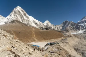
Gorak Shep is not technically a village in the permanent sense. Nobody lives here 12 months round. It’s a seasonal cluster of hotels that exists mainly to serve trekkers inside the final stretch, sitting on a flat, sandy lakebed that turned into a glacial lake. The name means “lifeless crow” in Tibetan, which tells you something about the environment.
At this elevation, everything takes more effort. Even climbing a short flight of stairs can leave you breathless. Sleep is shallow and regularly interrupted. Appetite drops. The accommodations here are the minimum fundamental at the whole route, cold rooms, thin mattresses, and food that can be easily prepared by using necessity in place of desire. Most trekkers spend one or two nights.
Gorak Shep serves as the base for two separate objectives:
- Everest Base Camp lies around 3 hours away through the Khumbu Glacier moraine, a rocky, uneven path that calls for careful footing. Most trekkers depart at dawn to reach Base Camp and go back to Gorak Shep through early afternoon.
- Kala Patthar (5,545m) is the highest factor most trekkers choose for views. Base Camp itself sits in a valley and offers restrained sightlines; Kala Patthar, a steep climb above Gorak Shep, offers an unobstructed panorama of Everest, Lhotse, Nuptse, and the complete higher Khumbu. Sunrise from Kala Patthar is one of the defining moments of the trek.
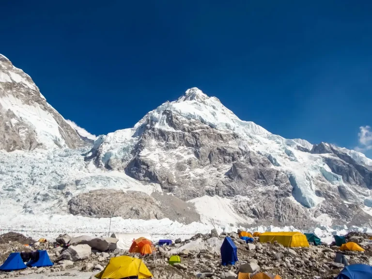
Beyond Gorak Shep: Base Camp Itself
Elevation: 5,364m. Role: Trek destination, not a village.
Everest Base Camp is not an agreement. During mountaineering season (roughly April to May), it is a temporary town of excursion tents spread throughout the Khumbu Glacier. Outside that window, it’s a marked point on a moraine with a sign and a view in part obscured through surrounding ridges. The satisfaction of reaching it is actual; however, it’s well worth knowing in advance that the destination is more symbolic than visual. The perspectives on the manner there, and from Kala Patthar above, are what most trekkers take into account the longest.
Where to Stay, Eat, and Rest Along the Way
Teahouses: What to Expect at Each Stage
Teahouses are the linchpin of the complete EBC route. Below Namche, they’re simply snug: non-public rooms with proper beds, connected lavatories in better motels, and menus extensive enough to fulfill maximum appetites. From Namche to Tengboche, requirements remain affordable. Above Dingboche, count on shared rooms, thinner blankets, and colder nights. By Lobuche and Gorak Shep, you’re dozing in the most primary situations of the trek.
Booking ahead throughout the high season (March to May and October to November) is strongly recommended from Namche upward. Lower villages have sufficient capability to soak up walk-ins, but the better resorts fill quickly, and turning up without a reservation at 4,900m is an uncomfortable situation.
Food: What’s Reliable and Where
Dal bhat is the most dependable meal on the complete route. Rice, lentil soup, vegetables, and often a small curry, it’s filling, warm, nutritious, and can be had everywhere. Many teahouses offer unlimited refills. At altitude, in which appetite shrinks, and your body needs calories, dal bhat does the process better than something else on the menu.
Namche deserves a specific mention for food. The bakeries here produce absolutely accurate bread, cinnamon rolls, apple pie, and filter coffee. It’s really worth consuming properly throughout your acclimatization days here because the menu quality drops progressively from this point on. Above Dingboche, stick with simple, cooked meals: soups, noodles, dal bhat, porridge. Avoid uncooked vegetables and salads at high altitudes, where water is more difficult to obtain.
Wifi and Charging
Wifi exists on the entire route from Lukla upward; however, reliability varies notably. Namche has nice connectivity on the trek. Above Dingboche, assume slower speeds and more frequent outages. Most teahouses charge a small charge for wifi get right of entry to, and the fee has a tendency to increase with altitude.
Charging your gadgets costs cash above Namche. Bring a powerful financial institution capable of more than one cost, specifically in case you’re counting on a cellphone for navigation or photography. Solar charging is available at a few lodges but is weather-dependent. A full packing list for trekking in Nepal covers the electronics and tools really worth bringing.
Frequently Asked Questions
How many villages are on the Everest Base Camp trek?
The general EBC route passes through about 14 settlements between Lukla and Gorak Shep, depending on which department you take on the Dingboche/Pheriche break-up. This matter includes small functional stops like Jorsale and Chheplung alongside predominant hubs like Namche Bazaar and Tengboche.
What is the biggest village on the EBC trek?
Namche Bazaar is the most important settlement on the path by a huge margin. With a permanent population, a weekly marketplace, complete-carrier lodges, eating places, equipment stores, and dependable internet, it serves as the economic and cultural capital of the Khumbu region.
Which village is best for acclimatization on the EBC trek?
Namche Bazaar is the primary essential acclimatization stop and the most essential. The general two-night time live right here gives your body time to adjust before crossing 4,000m. Dingboche serves as the second acclimatization stop, higher up, with a rest day hike to Nagarjun Hill at around 5,100m that prepares you for the final days to Base Camp.
What is the last village before Everest Base Camp?
Gorak Shep at 5,164m is the closing agreement before Base Camp. It’s a seasonal cluster of teahouses as opposed to a permanent village, and it serves as the overnight base for each of the Base Camp walk and the Kala Patthar dawn hike.
Is the Namche Bazaar rest day worth it?
Yes, without exception. The rest day serves a physiological reason: your body desires time at 3,440m earlier than mountain climbing higher. Beyond acclimatization, the day offers you time to go to the Sherpa Culture Museum, walk as much as Khumjung, explore the Saturday market if timing aligns, and eat nicely before the route gets more stressful.
Do all EBC routes pass through both Dingboche and Pheriche?
No. Dingboche and Pheriche sit down on parallel branches of the direction. Most cutting-edge itineraries pass through Dingboche. Some older or alternative routes use Pheriche. Your unique itinerary will take you through one, no longer each.
What is Sherpa culture like in the Khumbu villages?
The Khumbu’s Sherpa groups follow Tibetan Buddhist traditions, and that presence is seen at some stage in the trek: monasteries, mani stone walls, prayer wheels, and chortens mark every village and many path junctions. The hiking industry has delivered enormous financial trade to the region since the Fifties; however, Sherpa identity remains strongly tied to the mountains, the monasteries, and the seasonal rhythms of highland existence. The Sherpa Culture Museum in Namche gives the clearest creation of that history in approximately an hour.